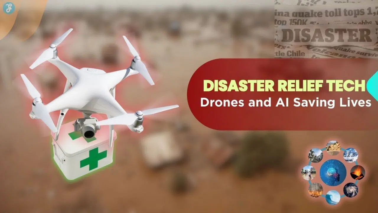
Have you ever watched a storm roll in and felt that sudden knot of worry in your stomach? Floods, wildfires, and hurricanes hit hard. They can turn normal life completely upside down in an instant. Naturally, you might worry about your family, your pets, or your home. Sometimes help does not arrive fast enough. Every single second counts. I have discovered something amazing while researching this topic. Drones can actually reach dangerous, blocked-off places much quicker than people on foot.
These flying helpers often spot survivors before ground rescue teams even arrive at the scene. I am going to walk you through exactly how “Disaster Relief Tech: Drones And AI Saving Lives” brings real hope during the toughest times. We will explore the facts, the tools, and the incredible results together.
Technology’s Impact on Disaster Relief
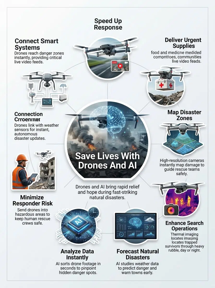
Smart tech is saving lives right now. With advanced tools, response teams help people faster and with much more care than ever before.
Rapid Response Importance
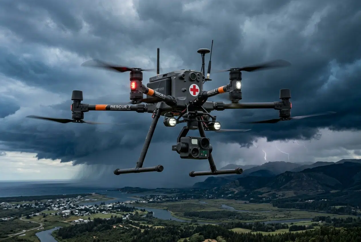
Seconds matter after a disaster strikes. Quick action often means the difference between life and death during search and rescue missions. Drones zip through damaged zones faster than trucks. They send live video back to base for instant situational awareness.
AI helps responders sort all this emergency data fast. The Pacific Northwest National Laboratory (PNNL) recently proved how effective this is.
A 2024 FEMA study found that using PNNL’s rapid analytics cut emergency response times by a full 25 percent.
A drone’s thermal imaging finds survivors trapped by rubble or floodwater, even in the pitch dark. Unmanned aerial vehicles eliminate delays that once slowed down emergency response teams.
Overcoming Traditional Management Challenges
Old ways of disaster management simply move too slowly. Paper maps, blocked roads, and shaky phone lines waste precious time.
Artificial intelligence changes the game entirely. For example, the US National Hurricane Center (NHC) now uses data-driven AI models to augment confidence in long-range storm tracking. They can predict development points multiple days faster than older methods.
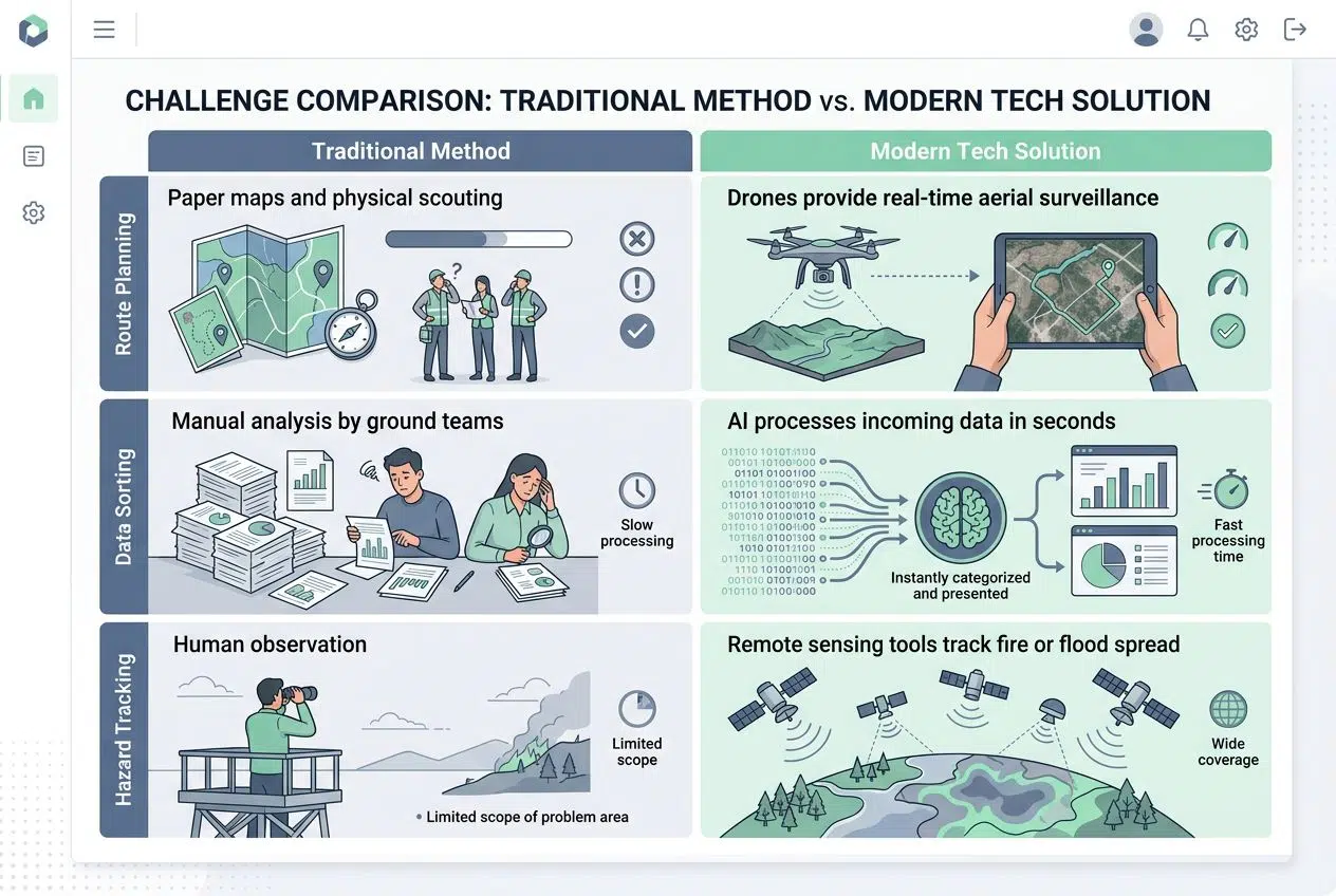
Here is a quick look at how old methods compare to modern tech:
| Challenge | Traditional Method | Modern Tech Solution |
|---|---|---|
| Route Planning | Paper maps and physical scouting | Drones provide real-time aerial surveillance |
| Data Sorting | Manual analysis by ground teams | AI processes incoming data in seconds |
| Hazard Tracking | Human observation | Remote sensing tools track fire or flood spread |
These tools help leaders make clear decisions more quickly. Remote sensing tools track the spread of fires or floods that humans cannot reach safely.
Utilizing Drones for Effective Disaster Relief
Drones swoop in fast to cover ground that trucks cannot reach. They snap clear pictures from above to shine a light on hidden dangers.
Supply and Food Delivery
People in disaster zones need food and supplies immediately. Unmanned aerial vehicles move goods quickly over very hard terrain.
- Helicopters are costly and loud. Drones offer cheap, quiet delivery for urgent humanitarian aid.
- Companies like Zipline use drones to deliver critical items. A recent medical study by Mateen et al. found that drones reduce the average delivery time of emergency medical supplies by 78.8 percent.
- Food drops easily reach flooded houses or cut-off communities. They skip broken roads entirely.
- Artificial intelligence plans the fastest flight paths so packages arrive exactly at the right spot.
- Drones use remote sensing to find safe drop zones. This keeps ground teams safe from aftershocks or unexpected fires.
Zone Mapping for Disaster Areas
Drones give rescue teams a clear view of disaster zones from above. This aerial surveillance brings important information right when it matters most.
- Drones with high-resolution cameras fly over damaged areas for real-time mapping.
- Software like Nearmap ImpactTriage AI speeds up the assessment. In 2023, just hours after Hurricane Idalia passed, this tool analyzed Keaton Beach in Florida and identified over 400 damaged buildings.
- Remote sensing with thermal imaging finds hot spots in fire zones. It also finds cold spots where people might be trapped.
- Emergency response teams use these maps to guide relief operations safely.
- Artificial intelligence reads these images fast. It points out blocked roads in seconds.
Enhancing Search and Rescue Efforts
After mapping the zones, teams use the data to start urgent search and rescue work. Fast action often means the difference between life and death in crisis management.
- Thermal imaging cameras spot body heat hidden by thick woods or debris.
- During Hurricane Idalia, the University of Georgia (UGA) Extension Emergency Preparedness Team used drones to quickly assess over 13,000 acres of crop and structural damage.
- Real-time data streams send information straight to emergency response centers.
- Artificial intelligence flags shapes or movements that might be missing persons.
- First responders guide drones into risky spots that humans cannot reach safely.
AI Advancements in Disaster Management
AI steps in with incredible speed. It marks danger spots on maps instantly, so help gets where people need it most.
Forecasting Natural Disasters
Artificial intelligence studies weather maps, satellite images, and sensor data to spot danger early. Early notice means rescue operations begin much sooner.
- In June 2025, Google debuted its DeepMind tropical cyclone model.
- This powerful AI tool produces ensemble forecasts with lead times of up to 15 days.
- Emergency response teams get more time to prepare supplies.
- Machines sift through rivers of data every hour to look for small signs of danger.
Analyzing Data for Real-Time Decisions
After systems predict a crisis, the next step is making sense of the data fast. Drones fly overhead to gather video and thermal images.
AI studies these feeds in seconds to pinpoint collapsed buildings or trapped people. Rescue teams do not need to guess where to go first.
For example, NOAA’s AI-Enhanced Storm Surge Model provided neighborhood-level flooding predictions 72 hours before Hurricane Idalia made landfall. These hyper-local forecasts enabled the precise evacuation of 127,000 residents.
Improving Emergency Communication
Artificial intelligence sorts and delivers alerts to emergency response teams in seconds. The US Department of Energy recently formed the First Five Consortium.
They partnered with Microsoft to scale deep learning algorithms that produce near-real-time data for first responders. This improves situational awareness drastically.
Clear communication saves lives during crisis management, especially when normal radio networks fail.
AI-powered radios connect search and rescue squads directly. Teams now get real-time data so they react quickly instead of guessing their next move.
Case Studies: Drones and AI in Action
See how new tools are shaking up disaster relief. These real-world stories show exactly how the tech works in the field.
Hurricane Idalia Initiatives
Drones flew over flooded Florida neighborhoods right after Hurricane Idalia hit. Unmanned aerial vehicles captured high-quality images for rapid damage assessment.
Companies stepped in with advanced modeling. One Concern used its Domino AI digital twin technology to predict power downtime across 10 heavily affected Florida counties. Their model displayed a median error of just -2.9 percent, accurately gauging the peak number of customers without power.
Aerial surveillance helped find people needing urgent help. It also delivered supplies by air where trucks could not go.
Maui Fires Search and Rescue
Burning winds hit Maui in 2023. Hundreds of homes were turned to ash, and emergency response teams rushed in with drones.
- Unmanned aerial vehicles flew over the area to capture video and thermal images.
- Pilots used this real-time data to guide search and rescue crews through hot zones.
- AI analyzed the footage fast to flag places where people were trapped.
- Researchers are now testing deep learning models like Transformers for wildfire prediction.
Recent 2025 tests show these specific AI models achieve 78.71 percent accuracy on California Wildfire datasets. This far outperforms older prediction methods.
Managing Floods in Central Texas
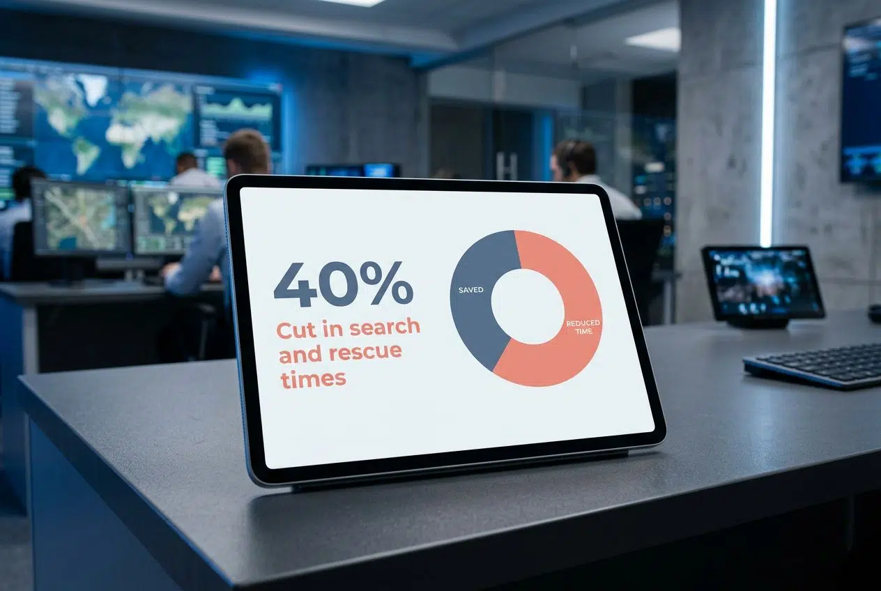
Floods can hit Central Texas very fast. Drones quickly fly overhead to spot stranded families on rooftops using aerial surveillance.
Emergency response teams use artificial intelligence for rapid flood zone mapping. They find safe paths through deep water using real-time data analysis.
Drones cut search and rescue times by more than 40 percent in complex environments, getting help to stranded families faster than ever before.
Thermal imaging provides situational awareness that is impossible for humans to manage alone in the dark. Fast help saved many lives during those tough days.
Advantages of Drones and AI in Disaster Scenarios
Drones and AI get help where it is needed fast. They beat traffic and spot trouble with incredibly sharp eyes.
Accelerating Response Times
Seconds mean everything in rapid relief. Unmanned aerial vehicles fly straight over blocked roads. A recent NASA report highlights how integrating satellite data with AI improves emergency response times by 30 percent. Quick relief drops food by air to reach cut-off families in minutes instead of hours.
Search teams use thermal imaging from the sky to spot survivors while storms still rage below. New tech beats delays caused by traffic jams and rough terrain.
Boosting Accuracy and Efficiency
Artificial intelligence spots problems fast. Drones use cameras to map damage without putting people at risk.
Unmanned aerial vehicles collect data from the sky in just minutes. Traditional teams might take hours or days for the same job.
The January 2025 Los Angeles wildfires cost an estimated $41 billion in insured losses. Fast AI assessments help process these massive claims much quicker.
Every detail gets counted, so food drops reach hungry families faster. Disaster relief tech shaves precious time off every step.
Minimizing Risk for Responders
Drones fly into storm zones or wildfires so human responders can stay safe. They capture real-time data for damage assessment without sending people into harm’s way.
- Drones fly right into heavy smoke or flooded streets.
- Human responders stay completely safe at the base station.
- ALERT California uses 1,200 active cameras paired with Microsoft AI.
- This setup gives first responders earlier situational awareness before they ever set foot in a dangerous area.
Tools like these keep emergency response workers one step ahead. They lower the chances of injury during crisis management duties.
Barriers to Technology Adoption in Disaster Relief
Technology can hit some roadblocks in disaster work. These hurdles keep response teams actively looking for fresh solutions.
Costs of Development and Deployment
Drones and AI tools cost money. Building a specialized drone for disaster recovery requires significant funding. Training the artificial intelligence systems and buying thermal cameras adds even more dollars to the budget. However, the investment is proving worthwhile. The market for commercial drone delivery alone is projected to exceed $5.6 billion by 2026.
Here is a breakdown of common deployment costs:
| Requirement | Financial Impact |
|---|---|
| Hardware | High initial cost for commercial-grade UAVs |
| Software | Ongoing fees for AI processing and secure cloud storage |
| Maintenance | Regular repairs needed after flying in rough weather |
Smaller groups handling humanitarian aid often find these costs hit hard. They slow down rapid relief efforts.
Data Security and Privacy Concerns
Sharing data from drones and artificial intelligence brings fresh worries. Personal details can leak if teams are not careful.
A 2025 study on the “Internet of Drones” (IoD) highlighted that drone networks face unique cyber threats. Attackers can attempt man-in-the-middle attacks, which threaten the confidentiality and integrity of emergency drone services.
Hackers target disaster management systems for personal gain. Many groups now use deep learning-based encryption to secure their networks. Staying careful helps keep people’s trust during a large-scale crisis.
Training for Advanced Technology Use
Protecting sensitive information is key. People must also know exactly how to use these tools legally and safely.
Emergency teams now rely heavily on drones and artificial intelligence. To fly these drones legally for commercial or government use in the United States, pilots must study for and pass the FAA Part 107 certification exam. This requires passing a strict 60-question test on airspace rules and safety procedures.
Hands-on sessions help workers operate equipment safely during search and rescue missions. Simple lessons on thermal imaging save lives.
The Future of Technology in Disaster Response
New tools spark hope for even faster rescue work. Here is what is coming to the field very soon:
- Smarter AI prediction models that learn from past storms.
- Deep IoT integration for instant data sharing.
- Fully autonomous flight paths that require zero human input.
Enhancing AI Prediction Models
AI prediction models keep getting smarter with more data from satellites and sensors. These tools spot patterns before floods hit towns hard.
Physics-based weather models like WRF-Fire are widely used but computationally expensive. AI and machine learning models solve this problem by capturing complex patterns instantly without needing massive supercomputers for every calculation.
Faster computers sort through weather reports in minutes. Real-time data analysis is now a standard tool for disaster management leaders.
Integrating IoT with Drones
Disaster teams are turning to smart tech that works together. Drones now talk with Internet of Things (IoT) devices like weather sensors on the ground.
Organizations need powerful systems to handle this immense data. For example, the National Ecological Observatory Network (NEON) partnered with Google Cloud to collect and manage over 400 terabytes of raw environmental data per year.
During wildfires, drones paired with remote weather stations track fire spread minute by minute. Lives get saved when technology shares one clear story.
Autonomous Systems for Disaster Response
Autonomous systems use artificial intelligence to help manage disasters while keeping people perfectly safe.
- Drones fly through storms without risking human lives.
- They carry water and map damaged zones with thermal imaging cameras.
- The FAA’s Beyond Visual Line of Sight (BVLOS) Rulemaking Committee is actively working to expand how these autonomous drones operate legally over long distances.
- AI sorts real-time data coming from these devices instantly.
Autonomous tech grows smarter every single day. It saves precious time during chaos.
Strengthening Disaster Relief Through Partnerships
Working together brings out the best results in tough times. Sharing knowledge saves more lives.
Government and Tech Company Collaborations
Government teams often join forces with big tech companies during disasters. Agencies like FEMA work closely with cloud providers for rapid relief. FEMA recently moved its National Flood Insurance Program (NFIP) to Google Cloud. This shift built a highly secure, scalable hub for processing massive amounts of disaster data.
| Partner | Contribution | Result |
|---|---|---|
| Government Agencies | Field operations and public safety authority | Organized, legal deployment of tech |
| Tech Giants | Cloud computing and AI algorithms | Real-time analytics and data processing |
These partnerships make it easier to solve problems on the fly.
Community Initiative Roles
Big projects are vital. Community action keeps disaster relief moving quickly at the local level. Local volunteers use their own drones for aerial surveillance in their neighborhoods. They use apps like Aloft Air Control, which processes legal FAA airspace requests, to safely coordinate their flights during recovery efforts.
Neighbors feed real-time data into AI systems to check on vulnerable folks next door. This teamwork improves situational awareness for everyone involved.
The Value of Global Partnerships
Disaster relief tech grows much faster with help from around the globe. Governments, tech companies, and aid agencies share skills and tools.
Organizations like the Commercial Drone Alliance (CDA) work with aviation authorities to create standard operating protocols that improve safety worldwide. Shared maps made by drones provide clear situational awareness to everyone. With more hands helping out, emergency response reaches people sooner. It improves crisis management everywhere.
Closing Thoughts
Drones, artificial intelligence, and fast data give real hope after a disaster strikes. These incredible tools fly right over danger zones to spot survivors using thermal imaging. They map the severe damage in real time. Every single second matters during an emergency response.
Drones cut rescue times by hours or even days. Just like we saw during the Maui wildfires and Hurricane Idalia, unmanned aerial vehicles bring vital aid to trapped people. They improve situational awareness for search crews instantly. Artificial intelligence now helps forecast storms and floods with startling accuracy. Fast analysis of data allows teams to direct humanitarian aid smartly instead of guessing.
Technology keeps changing how we handle disaster management. It acts like extra eyes and brains for every team working hard on the ground. Ultimately, Disaster Relief Tech: Drones And AI Saving Lives is reshaping the very future of how we help each other.