

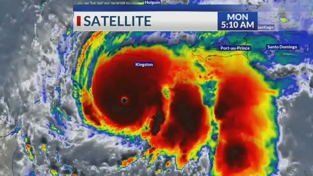
Jamaica is on its highest state of alert today, October 28, 2025, bracing for a potentially catastrophic direct hit from Hurricane Melissa. Now a monstrous Category 5 storm, it is the strongest tropical cyclone globally this year and threatens the island’s southern coast with “unsurvivable” storm surge, devastating winds, and life-threatening flash floods.
The Threat from Melissa
- Storm Status: Category 5 Hurricane (Saffir-Simpson Scale)
- Max Winds (as of 10:00 AM): 180 mph (290 km/h) with higher gusts.
- Location (as of 10:00 AM): Approx. 90 miles (145 km) southeast of Morant Point, Jamaica.
- Movement: West-northwest (WNW) at 12 mph (19 km/h).
- Forecasted Landfall: Eyewall expected to cross the coast near the St. Thomas / Kingston border between 11:00 PM Tuesday and 3:00 AM Wednesday.
- Primary Threats: “Unsurvivable” storm surge of 20-25 feet; widespread rainfall of 15-25 inches; catastrophic landslides.
- Govt. Response: Mandatory evacuation orders for over 250,000 people in coastal and low-lying zones. National shutdown in effect.
A ‘Meteorological Nightmare’: Melissa’s Path and Power
Hurricane Melissa has alarmed meteorologists with its textbook rapid intensification. Just 48 hours ago, it was a disorganized tropical storm. Fueled by exceptionally warm sea surface temperatures and low wind shear, it exploded in strength, intensifying from a Category 2 to a Category 5 storm in less than 18 hours overnight—a “meteorological nightmare” for any island in its path.
The 10:00 AM Advisory
The latest bulletin from the U.S. National Hurricane Center (NHC) paints a grim picture. This track places the island’s densely populated capital, Kingston, and the vulnerable, low-lying communities of St. Catherine (including Portmore) on the devastating “dirty” right-hand side of the storm.
Latest Storm Position (10:00 AM, Oct 28)
- Location: 17.2°N, 75.5°W (90 miles SE of Morant Point)
- Minimum Central Pressure: 915 mb
- Hurricane-Force Winds Extend: 60 miles (95 km) from the center.
- Tropical-Storm-Force Winds Extend: 175 miles (280 km) from the center.
This storm is the strongest to form in the Atlantic basin since 2019’s Hurricane Dorian and the strongest global storm of 2025. Its pressure and wind speeds rival those of Hurricane Gilbert (1988) and Hurricane Ivan (2004), two storms etched into Jamaica’s national memory for their widespread destruction.
‘Do Not Wait’: Government Orders Mass Evacuations
The Government of Jamaica has initiated a full-scale national emergency response. The Office of Disaster Preparedness and Emergency Management (ODPEM) moved the entire island to a “Hurricane Warning” late Monday, triggering the activation of over 900 national shelters.
Prime Minister Andrew Holness, in a somber emergency broadcast, issued a stark warning to citizens in the path of the storm.
“This is not a storm to be trifled with. This is a national crisis,” declared Prime Minister Holness. “We have issued mandatory evacuation orders for all vulnerable coastal and low-lying areas. For your safety, for your life, you must move to a shelter now. Do not wait. The JDF [Jamaica Defence Force] and JCF [Jamaica Constabulary Force] are being deployed to assist, but there will be a point where they, too, must seek shelter. Your life is your responsibility. Please, act now.”
Infrastructure Shutdown
In preparation for the impact, all national utilities are enacting shutdown protocols:
- Airports: Both Norman Manley (Kingston) and Sangster (Montego Bay) international airports ceased operations at 6:00 AM today.
- Power Grid (JPS): The Jamaica Public Service (JPS) has warned of a “controlled shutdown” of the national grid as winds reach dangerous levels to prevent cascading failures. Widespread, long-term outages are expected.
- Water (NWC): The National Water Commission (NWC) has shut down many of its systems due to high turbidity (muddy water) and to protect equipment, urging residents to rely on stored water.
By the Numbers: The Catastrophic Threats
The primary dangers from Melissa are threefold: wind, water, and earth.
1. The ‘Unsurvivable’ Surge
The Jamaica Meteorological Service (Met Service) has issued its most dire warning for storm surge. The combination of Melissa’s intense low pressure and powerful onshore winds is expected to push a catastrophic wall of water onto the southern coast.
Storm Surge Forecast (Peak)
- St. Thomas & Eastern St. Andrew: 20 to 25 feet (6 – 7.6 meters)
- Kingston Harbour & Portmore: 15 to 20 feet (4.5 – 6 meters)
- Impact: This level of surge will cause “unsurvivable” inundation, destroying coastal structures, cutting off the Norman Manley Highway to the airport, and completely flooding communities like Portmore, which sits largely at or below sea level.
2. Inland Flooding & Landslides
The storm’s slow-for-its-latitude movement will allow it to dump immense amounts of water.
3. Rainfall & Landslide Risk Analysis
- Widespread Rainfall: 15 to 25 inches (380-635 mm) across eastern and southern parishes (St. Thomas, Portland, St. Andrew, Kingston, St. Catherine).
- Isolated Totals: Up to 35 inches (890 mm) in the Blue and John Crow Mountains.
- Soil Saturation: The National Works Agency (NWA) confirms that soil saturation from a wet October is already at 95% in upland areas. This makes catastrophic, life-threatening landslides not just a risk, but a near-certainty in hilly communities in St. Andrew, St. Thomas, and Portland.
‘The Shelters are Filling’: A Scramble for Safety
On the ground, the mood is one of grim determination. Reports from Kingston, St. Andrew, and St. Thomas show highways gridlocked as tens of thousands heed the evacuation orders, while others make last-minute runs on supermarkets and hardware stores.
Shelves for batteries, water, bread, and tinned goods are bare. Long, winding lines persist at gas stations.
“People are taking this one seriously. I’ve never seen the lines for gas this long,” said Michael-Sean, a resident of Harbour View, in a social media video post. Harbour View is a coastal community east of Kingston under mandatory evacuation. The shelter at the primary school is already filling up. We are just praying..
Disaster coordinators report that while shelters are filling, many residents in known high-risk zones are choosing to “ride out the storm,” a decision officials have called “a potential death sentence.
All residents in the warning area must have preparations completed. The window for safe movement is closing rapidly.
- Tuesday Afternoon (Oct 28): Outer rainbands and tropical-storm-force winds will make travel impossible. Conditions will deteriorate rapidly by 2:00 PM. All non-essential movement must cease by 6:00 PM.
- Tuesday Night – Wednesday Morning (Oct 28-29): The eyewall, containing the 180 mph winds, is expected to make landfall. This is when catastrophic damage will occur. All power and communication systems are expected to fail.
- Wednesday Afternoon (Oct 29): Melissa’s center is projected to be north of the island, moving toward Cuba. However, life-threatening flash flooding and mudslides from the “tail” of the storm will continue for at least 24-36 hours.
Hurricane Melissa represents one of the most significant meteorological threats in Jamaica’s modern history. The preparations are complete; the warnings have been issued. As the sky darkens and the first powerful winds begin to lash the coast, a nation of nearly 3 million people now holds its breath and waits.
The information is Collected from BBC and NBC News.