
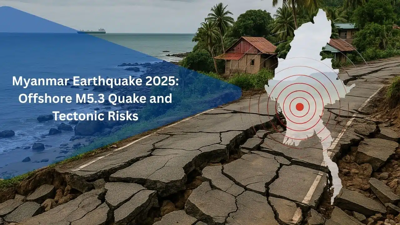
Myanmar experienced a moderate earthquake on Sunday morning, November 23, 2025, when a magnitude 5.3 tremor struck off the country’s coast. The quake was strong enough to be felt across parts of Myanmar and in neighboring Thailand, but no damage or casualties had been reported in the initial hours after the event, according to local authorities and regional monitoring centers.
Instrumental readings from international seismological agencies indicate that the quake occurred at a shallow depth of around 10 kilometers, which typically makes shaking more noticeable at the surface even when the magnitude is in the moderate range.
Time and Location of the Tremor
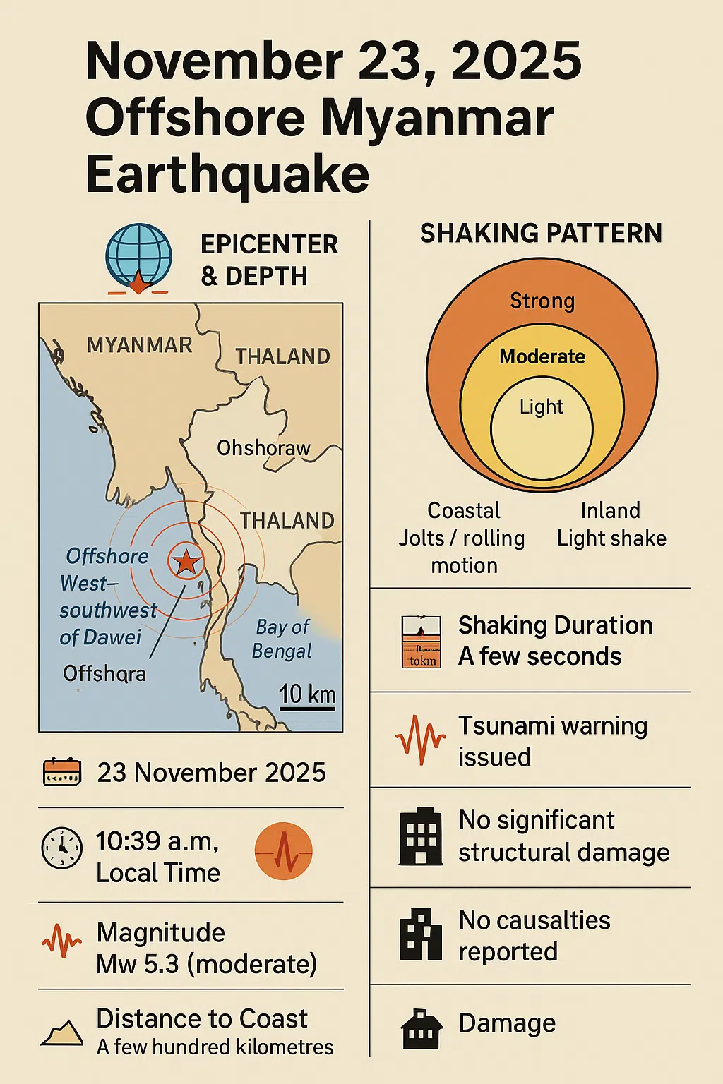
The tremor was recorded at 10:39 a.m. local time (Myanmar). Its epicenter was offshore, roughly a few hundred kilometers west–southwest of a coastal city in southern Myanmar—in line with early reports that placed it around 267 kilometers west–southwest of Dawei (often spelled Dawei/Daoi in local transliteration), near the eastern margin of the Andaman Sea.
This offshore setting meant that the strongest shaking occurred over the sea rather than directly under dense population centers. Residents in coastal Myanmar reported light to moderate shaking, and people in parts of Thailand—especially areas closer to the Andaman coast—also described feeling a mild tremor that lasted a few seconds.
Why a Magnitude 5.3 Still Matters
On the modern moment magnitude scale, a 5.3 event is classified as moderate. It is typically too small to cause widespread structural damage in areas with reasonably built infrastructure, especially if it occurs offshore. However:
- It can shake buildings, rattle windows, and unsettle residents.
- Poorly constructed or already weakened structures may be vulnerable.
- It serves as a reminder that Myanmar and its neighbors sit in a very active seismic zone, where significantly larger events are possible and have occurred in recent years.
For communities still traumatized by the devastating magnitude 7.7 earthquake near Mandalay in March 2025, even a moderate tremor is enough to heighten anxiety and renew questions about preparedness.
What We Know About the Epicenter, Depth, and Shaking Pattern
Seismologists will likely use this earthquake to refine their understanding of how ground motion travels from offshore sources toward Myanmar’s coastline and inland regions. By comparing instrumental recordings with what people reported feeling in different towns, they can build a clearer picture of where shaking tends to be amplified and where it tends to be dampened. This, in turn, helps improve future intensity maps and hazard zoning, especially for coastal districts that might be affected by similar offshore events.
Over time, a catalogue of moderate quakes like this one becomes a practical reference for engineers and planners. Each event adds another datapoint about how local soils, reclaimed land, river deltas, and bedrock hills respond to the same magnitude and depth of shaking. That level of detail is critical when deciding where to allow new high-rise construction, where to reinforce older buildings, and where critical infrastructure such as ports, fuel depots, and power plants should be designed to higher standards.
Offshore Epicenter in the Andaman Sea
Preliminary location data suggest that the epicenter lies in the offshore region west of Myanmar’s mainland, within the broader Andaman Sea – eastern Bay of Bengal setting. That area lies above a complex boundary where the Indian Plate is subducting beneath the Burma Plate and related crustal blocks.
Because the event occurred offshore:
- The strongest ground motion likely took place beneath the seabed.
- Coastal regions felt the shaking as short, rolling motion or quick jolts, depending on local geology.
- Inland areas, including parts of Thailand, experienced diminished but still perceptible shaking.
Shallow Depth and Its Effect on Intensity
The reported focal depth of around 10 km is considered shallow by seismological standards. Shallow quakes transmit energy to the surface more efficiently than deep ones. For this event, several implications follow:
- People relatively close to the epicenter would have felt it clearly, even if it remained moderate in magnitude.
- Intensity—how strong the shaking feels in different places—would vary. Areas with soft sediments, such as deltas and coastal plains, can experience amplified shaking, whereas hard bedrock regions feel less motion.
- The earthquake was not large enough to cause the severe levels of intensity typically associated with structural collapse, particularly given its offshore location.
Why No Major Damage Was Reported
Several factors help explain the absence of early damage or casualty reports:
- Offshore Location: The epicenter was located far from dense urban centers, reducing direct impact on buildings and infrastructure.
- Moderate Magnitude: A magnitude 5.3 quake can cause minor damage near the epicenter, but substantial destruction is more commonly associated with magnitudes above 6.0, especially when combined with shallow depth and vulnerable buildings.
- Short Duration of Strong Shaking: For moderate-magnitude events, the strongest shaking usually lasts only a few seconds. That short burst of motion is frightening but often insufficient to cause widespread structural failure, unless buildings are already critically weakened.
- Early Awareness of Seismic Risk in the Region: After the March 2025 Mandalay earthquake, awareness of seismic risk in Myanmar has increased, prompting at least some level of informal preparedness and greater public sensitivity to tremors.
Key Parameters of the November 23, 2025 Offshore Myanmar Earthquake
| Parameter | Detail |
|---|---|
| Date | 23 November 2025 |
| Local Time | 10:39 a.m. (Myanmar) |
| Magnitude | Mw 5.3 (moderate) |
| Epicenter | Offshore, west–southwest of Dawei, Bay of Bengal / Andaman Sea |
| Distance to Coast | A few hundred kilometers from Dawei |
| Focal Depth | ~10 km (shallow) |
| Shaking Duration | A few seconds |
| Strongest Shaking | Beneath the seabed |
| Areas Affected | Southern Myanmar, western Thailand |
| Tsunami Warning | None issued |
| Damage | No significant structural damage |
| Casualties | None reported |
Human Impact and Early Emergency Response
Beyond the purely physical effects, the earthquake had an emotional and social dimension. In villages and smaller towns, local leaders, religious institutions, and community groups often play an informal role in calming residents, sharing basic safety information, and encouraging people to check on elderly neighbors or families with small children. These quiet acts of solidarity are rarely captured in official reports, but they are part of the real human response every time the ground moves.
For emergency agencies, this event also serves as a live test of communication channels—from national alerts and local radio announcements to social media posts and community messaging apps. It reveals where information flows smoothly and where bottlenecks or confusion still exist. Lessons learned from this moderate quake can be used to adjust protocols, fine-tune message wording, and strengthen cooperation between central authorities and local administrators before a larger emergency happens.
Initial Public Reaction in Myanmar
Residents in parts of Myanmar said they felt brief but noticeable tremors. In coastal towns and smaller cities, people reported:
- Light shaking of furniture and hanging objects.
- A low rumbling sound, similar to distant thunder or a heavy vehicle passing.
- A short moment of confusion, followed by people stepping outside as a precaution.
In many communities, memories of the Mandalay 7.7 quake remain raw. Even moderate tremors can trigger psychological stress, particularly for families who lost relatives or homes in March 2025. While Sunday’s event did not repeat that level of devastation, it tapped into underlying fears and underscored how fragile everyday stability can feel in a seismic zone.
Tremors in Neighboring Thailand
The earthquake’s waves traveled across borders and were felt in parts of Thailand, particularly in areas closer to Myanmar and the Andaman coast. Reports described:
- Light shaking in upper stories of buildings.
- Slight swaying of hanging lights and ceiling fans.
- A small number of people stepping outside office buildings and shops until the shaking stopped.
No serious damage or injuries were reported in Thailand either. Local seismic networks and national disaster agencies monitored the event and confirmed its offshore origin, which lowered the risk of direct structural impacts.
Emergency Monitoring and Rapid Assessments
Within minutes of the quake, global and regional monitoring agencies had registered the event and published preliminary parameters (magnitude, location, depth). National disaster management agencies in Myanmar began their standard procedures:
- Checking critical infrastructure, such as major roads, bridges, and power facilities in the most affected regions.
- Communicating with local officials and police stations to identify any immediate damage or casualties.
- Monitoring telecommunications networks for disruptions or spikes in traffic linked to panic.
As of the first assessments:
- No collapsed buildings had been reported.
- No casualties or serious injuries were confirmed.
- Basic services—electricity, phone lines, transport—were functioning normally.
Why No Tsunami Warning Was Issued
Despite the offshore epicenter, the moderate magnitude of 5.3 and initial focal mechanism solutions suggested that this was not the type of event likely to generate a damaging tsunami. Tsunami-generating earthquakes are usually:
- Larger in magnitude (typically above 6.5–7.0).
- Involving significant vertical displacement of the seabed, which rapidly displaces water.
In this case, regional centers monitored sea level instruments and tsunami detection systems, but no abnormal sea-level changes were reported, and no tsunami alerts were issued.
Public Guidance: Stay Alert, Not Alarmed
Authorities and experts emphasized a balanced message:
- People were urged to remain calm and avoid spreading rumors.
- At the same time, residents were reminded of basic earthquake safety practices:
- Know safe spots indoors (under a sturdy table, away from windows).
- Identify clear evacuation paths if you must exit a building after shaking stops.
- Keep an emergency kit with water, basic medicines, and a flashlight.
- Know safe spots indoors (under a sturdy table, away from windows).
The Myanmar event, though moderate, serves as a real-time safety drill for populations across the region, reinforcing the need for personal and community-level preparedness.
A Busy Seismic Week: Links to the Bangladesh Quake
Two days before Myanmar’s offshore quake, on Friday, November 21, 2025, a magnitude ~5.5–5.7 earthquake in central Bangladesh shook Dhaka and surrounding areas. That event:
- Occurred near Narsingdi/Ghorashal, just east of the capital.
- Prompted mass evacuations from buildings in Dhaka.
- Led to multiple deaths and hundreds of injuries, mostly due to falling debris and panic during escape, not wholesale structural collapse.
It’s natural for people to ask whether the Bangladesh and Myanmar events form a single escalating sequence. Seismologists are cautious:
- Aftershocks, in the strict sense, occur near the same rupture zone as the mainshock, sharing its fault system.
- The Bangladesh quake and the offshore Myanmar quake are hundreds of kilometers apart, in different but interacting tectonic settings — intracontinental crust near Bangladesh vs. offshore subduction/fore-arc region near Myanmar.
A more accurate description is that both quakes are part of an actively deforming plate-boundary network, rather than a simple mainshock–aftershock pair. They reflect how stress is constantly redistributed across the larger India–Burma–Sunda system, not a neat domino chain moving from Dhaka to the Andaman Sea.
Major Regional Earthquakes in and Around the Burma Plate in 2025
| Event | Date | Magnitude | Location / Fault Context | Main Impacts |
|---|---|---|---|---|
| Mandalay Earthquake | 28 March 2025 | ~Mw 7.7 | Sagaing Fault, Central Myanmar | Wide damage, high casualties |
| Central Bangladesh Quake | 21 November 2025 | ~Mw 5.5–5.7 | Narsingdi/Ghorashal near Dhaka | Injuries, panic, structural failures |
| Offshore Myanmar Quake | 23 November 2025 | Mw 5.3 | Offshore Dawei, subduction/fore-arc | Light shaking, no major damage |
The Burma Plate: A Small Plate With Outsized Influence
To understand why quakes in Bangladesh, Myanmar, India, China, and Thailand can be linked in public discussion, we have to look at the Burma Plate (often called the Burma microplate).
Geophysically:
- It’s a minor tectonic plate, about 1.1 million km² in area.
- It sits between the Indian Plate to the west and the Sunda / Eurasian Plate to the east.
- It moves generally northward by a few centimeters per year, reflecting the ongoing convergence between India and Southeast Asia.
Its boundaries are crucial:
- West / Southwest: The Sunda–Andaman trench, where the Indian Plate subducts beneath the Burma Plate, forming the Indo-Burma subduction zone and the Andaman–Nicobar segment of one of the world’s most active subduction systems.
- East: The Sagaing Fault and related transforms in Myanmar and the Andaman Sea, which define a major strike-slip boundary with the Sunda Plate and cut close to cities like Mandalay, Nay Pyi Taw and Yangon.
Over millions of years, plate collision, rotation, and back-arc spreading have:
- Opened the Andaman Sea as a back-arc basin.
- Created complex fault networks running from the foothills of the Himalayas, through the Indo-Myanmar Ranges, down to the Andaman–Sumatra trench.
The November 23 offshore quake fits neatly into this setting: a moderate adjustment somewhere in or near the Burma Plate’s subduction and fore-arc region, not a random tremor in an otherwise quiet zone.
Tectonic Roles of Key Countries Around the Burma Plate
| Country | Plate Position & Role | Primary Seismic Characteristics |
|---|---|---|
| India | Pushes into Eurasia and subducts beneath Burma Plate | Himalayan quakes; Indo-Burma subduction system |
| Bangladesh | Located in Bengal Basin between India, Himalayas, Indo-Burma Ranges | Soft sediments amplify shaking; seismic risk near Dhaka |
| Myanmar | Rests largely on the Burma Plate | Sagaing Fault; subduction offshore; both crustal & megathrust quakes |
| China (Yunnan) | Part of Eurasian/Sunda margin interacting with Burma Plate | Strike-slip and thrust faults; frequent crustal earthquakes |
| Thailand | On Sunda Plate but influenced by Andaman–Burma tectonics | Tsunami exposure; shaking felt from Andaman Sea events |
How India, China, Myanmar, Thailand and Bangladesh Are Connected
The key to the region’s seismic story is that these five countries share the same tectonic machine. The Burma Plate acts like a hinge or buffer between the Indian and Sunda/Eurasian Plates. Stress in one area can subtly influence others, even if it doesn’t trigger direct aftershocks.
India: The Driving Force on the Western Flank
The Indian Plate is the main “engine” pushing into Eurasia, driving both:
- The Himalayan collision that continues to uplift the world’s highest mountain range.
- The oblique subduction of India beneath the Burma microplate along the Indo-Burma arc to the east.
In northeastern India, the plate boundary becomes especially complex:
- The Shillong Plateau and surrounding region form a thick, uplifted block at the edge of India.
- To the east, the Indo-Burma (Indo-Myanmar) Ranges rise as India dives beneath Burma, creating a broad, seismically active wedge from Nagaland and Manipur down through western Myanmar.
Many of the region’s largest historical earthquakes — including major events in Assam and the broader northeastern Indian region — occurred in this tangled border zone.
Bangladesh: A Delta on the Edge of Multiple Plates
Bangladesh sits atop the Bengal Basin, between:
- The Indian Shield to the west.
- The Himalayan foredeep and Shillong Plateau to the north.
- The Indo-Myanmar Ranges / Burma Plate to the east.
This location makes Bangladesh:
- A downstream receiver of sediments from the Ganges–Brahmaputra–Meghna rivers, building thick layers of soft delta deposits.
- A tectonically flexing region, where subsidence, sediment loading, and compressional forces from both the Himalayas and the Indo-Burma Ranges interact.
Soft, water-saturated sediments can amplify shaking, which partly explains why even moderate quakes — like the November 21 event — can cause significant panic, non-structural damage, and injuries in Dhaka and nearby towns.
Myanmar: Sitting on the Burma Plate Itself
Myanmar occupies a central position in this tectonic puzzle:
- Its western ranges (Arakan / Rakhine and Indo-Myanmar Ranges) form the fore-arc wedge above the subducting Indian Plate.
- Its central lowlands host the Central Myanmar Basin, a zone of crustal deformation and sedimentation.
- The Sagaing Fault runs north–south through the country, accommodating major strike-slip motion between the Burma and Sunda Plates and passing near key cities like Mandalay, Nay Pyi Taw, and Yangon.
As a result, Myanmar faces two major earthquake types:
- Subduction / megathrust events offshore (capable of tsunamis).
- Crustal strike-slip earthquakes on the Sagaing and related faults (like the March 28, 2025 Mandalay quake).
The November 23 M5.3 quake belongs to the offshore, plate-boundary part of this system, while the March 7.7 event was an onshore, crustal rupture — different styles of failure, same regional stress field.
China (Yunnan): The Northern Anchor of the System
Southwestern China, especially Yunnan, forms part of the Eurasian / Sunda Plate margin adjacent to the Burma microplate. Maps of the region show:
- The Himalayan syntaxis and associated thrust systems bending around into Myanmar.
- Complex networks of strike-slip and extensional faults (including the Red River and related systems) that help accommodate India’s push into Eurasia.
This means that large earthquakes in Yunnan and the eastern Himalaya are part of the same broad collision and escape tectonics that also drive deformation in Myanmar and the Indo-Burma ranges. China’s southwestern provinces and Myanmar are thus tectonically coupled, even if they sit on different formal plates.
Thailand: On the Sunda Plate, Feeling the Burma Plate’s Movements
Most of Thailand lies on the Sunda Plate, which extends beneath mainland Southeast Asia. Yet western Thailand and the Andaman Sea form a transition zone where:
- The Indian Plate subducts beneath the combined Burmese–Sunda margin, continuing south into the Sumatra trench.
- Strike-slip and transtensional faults, such as those in the Andaman Basin Central Fault Zone, accommodate back-arc spreading and complex rotation of crustal blocks.
This is why earthquakes offshore Myanmar and in the Andaman Sea are often felt in Phuket, Ranong, and other Thai coastal areas, especially on upper floors. The plates do not stop at political borders, and neither do seismic waves.
Vertical vs Horizontal Motion: Why Mechanism Matters
Earthquakes around the Burma Plate fall broadly into two families:
- Megathrust / subduction events
- Occur where the Indian Plate dives beneath the Burma Plate along the Sunda–Andaman trench.
- Involve vertical uplift or subsidence of the seafloor.
- Are the main generators of tsunamis.
- Occur where the Indian Plate dives beneath the Burma Plate along the Sunda–Andaman trench.
- Strike-slip / transform events
- Occur on faults like the Sagaing Fault in Myanmar and related structures in the Andaman Sea and Sumatra.
- Mostly involve horizontal sliding of crustal blocks.
- Can be extremely damaging on land (as in March 2025) but are usually less efficient at producing large tsunamis.
- Occur on faults like the Sagaing Fault in Myanmar and related structures in the Andaman Sea and Sumatra.
The November 23 M5.3 event, given its modest magnitude and lack of tsunami signals, is more consistent with a smaller-scale crustal adjustment in this plate-boundary zone than a major megathrust rupture.
Why Myanmar Is So Earthquake-Prone
Myanmar’s exposure to earthquakes is not a short-term phenomenon linked to a single fault or a brief “active phase”; it is the result of long-term tectonic forces that have been shaping the region for millions of years and will continue to do so far into the future. The slow but relentless motion of tectonic plates means that stress is constantly building along faults and plate interfaces, occasionally released in small to moderate earthquakes and, more rarely, in large, destructive ones.
Because major cities, transport corridors, and economic hubs lie within this active zone, seismic risk is woven into the country’s development story. Any long-range plan for urban growth, industrial expansion, or critical infrastructure—from dams and pipelines to ports and logistics hubs—must take this tectonic reality into account. Recognizing Myanmar as a fundamentally earthquake-prone country is the first step toward designing policies, building codes, and public investments that are realistic about the hazards and proactive about reducing them.
A Country at a Plate Boundary Crossroads
Myanmar sits at a geologically complex junction where the Indian Plate, the Eurasian Plate, the Sunda Plate, and the Burma Plate (or Burma microplate) interact.
This setting has several consequences:
- Myanmar lies along an active segment of the broader Indo–Eurasian collision zone, which is responsible for the uplift of the Himalaya and widespread seismicity across South and Southeast Asia.
- To the west and southwest, the Indian Plate subducts beneath the Burma Plate along the Sunda–Andaman trench system, generating large megathrust earthquakes and tsunamis.
- Through central Myanmar, the Sagaing Fault, a major right-lateral (strike-slip) transform fault, accommodates a large portion of the horizontal sliding motion between the Indian and Sunda–Burma system.
Together, these plate interactions make Myanmar one of the more earthquake-prone countries in the region, with both crustal strike-slip earthquakes on faults like Sagaing and subduction-related events originating offshore.
The Sagaing Fault: Myanmar’s Major Seismic Artery
The Sagaing Fault runs roughly north–south through Myanmar and is one of the country’s most significant seismic structures.
Key characteristics:
- It is a right-lateral transform fault, meaning the two sides of the fault slide past each other horizontally.
- It stretches from near the Eastern Himalayan syntaxis in the north down to the Andaman Sea in the south.
- It passes close to or beneath major cities such as Mandalay, Nay Pyi Taw, and Yangon, making it particularly important for seismic risk planning.
The M7.7 earthquake on March 28, 2025 near Mandalay is widely interpreted as a large strike-slip event associated with this fault system or a closely related structure, illustrating its capacity for destructive earthquakes when long-locked segments finally rupture.
Other Seismic Belts in Myanmar
Beyond the Sagaing Fault, Myanmar hosts several other active tectonic belts:
- The Burma seismic zone in western Myanmar, where the Indian Plate’s underthrusting beneath the Burma Plate drives crustal deformation and earthquakes.
- The Arakan Yoma (Rakhine) ranges, influenced by both collision and subduction processes.
- Offshore regions in the Andaman Sea and eastern Bay of Bengal, where subduction geometry, bends in the trench, and small crustal blocks combine to create complex seismic sources.
The November 23 offshore M5.3 quake fits within this broader context. Even if it did not occur directly on the Sagaing Fault, it reflects the ongoing strain release along plate boundaries involving the Burma Plate.
The Burma Plate and Its Adjacent Tectonic Boundaries
The close timing between the Bangladesh quake and the offshore Myanmar event naturally leads people to wonder whether they are part of a single escalating sequence. From the public’s perspective, what matters most is not the strict scientific definition of an aftershock, but whether these events suggest a heightened level of danger in the near term. Authorities therefore have to communicate carefully, explaining that while the region is clearly active, there is no evidence of a specific “chain reaction” that allows precise short-term predictions.
At the same time, the clustering of noticeable quakes across borders reinforces the idea that seismic risk does not stop at national frontiers. It encourages a regional view in which Bangladesh, Myanmar, India, and Thailand see themselves as sharing a connected tectonic environment. This perspective can support stronger cross-border collaboration on monitoring networks, data sharing, emergency drills, and even public education campaigns that use consistent messages about what people should do when they feel shaking.
What Is the Burma Plate?
The Burma Plate—sometimes called the Burma microplate—is a minor tectonic plate in Southeast Asia. It is often treated as a sliver or fore-arc block sandwiched between larger plates.
Important features:
- It lies between the Indian Plate to the west and the Sunda Plate (part of the broader Eurasian margin) to the east.
- It includes parts of western Myanmar, the Andaman Sea, and extends toward the Andaman and Nicobar Islands.
- It moves roughly northward at several centimeters per year, reflecting the relative convergence between India and the Southeast Asian margin.
This microplate is not a static piece of crust; it is an actively deforming block bound by major faults and trenches that store and release tectonic stress through earthquakes.
Boundary With the Indian Plate: The Sunda–Andaman Trench
To the west and southwest, the Burma Plate is bounded by the Indian Plate along the Sunda–Andaman trench system.
Here:
- The Indian Plate dives beneath the Burma Plate in a highly oblique subduction process.
- This boundary is capable of producing megathrust earthquakes, the kind that can trigger significant tsunamis.
- Historical and instrumental records show large, shallow earthquakes along this boundary, including events that contributed to major tsunamis in the Indian Ocean.
The offshore M5.3 earthquake near Myanmar’s coast likely occurred within the plate interface or in the overriding plate near this subduction boundary, though precise fault geometry for such moderate events often takes time to resolve.
Boundary With the Sunda Plate: Strike-Slip and Crustal Deformation
To the east, the Burma Plate transitions into the Sunda Plate (the main plate underlying much of mainland Southeast Asia).
Key aspects:
- The relative motion between the Burma Plate and the Sunda Plate is primarily strike-slip (horizontal), expressed prominently by the Sagaing Fault.
- This setting creates onshore crustal earthquakes that can directly impact cities and infrastructure inside Myanmar.
- GPS and geodetic studies show that some portion of the overall India–Sunda convergence is partitioned into this lateral motion, which explains why the Sagaing Fault and other nearby structures remain seismically active.
Vertical vs. Horizontal Motion: Why Mechanism Matters
Earthquakes around the Burma Plate boundaries can be broadly grouped by their faulting style:
- Megathrust/Subduction Events
- Occur on the interface where the Indian Plate dives beneath the Burma Plate.
- Involve significant vertical motion of the seafloor.
- More likely to generate tsunamis, especially if magnitudes exceed about 7.0.
- Occur on the interface where the Indian Plate dives beneath the Burma Plate.
- Strike-Slip/Transform Events
- Occur on faults like the Sagaing Fault or related structures in the Andaman Sea.
- Involve sideways sliding of crustal blocks.
- Can be highly destructive on land (as seen in March 2025), but usually less efficient at generating large tsunamis because vertical displacement of the seabed is limited.
- Occur on faults like the Sagaing Fault or related structures in the Andaman Sea.
The November 23 M5.3 event, given its moderate magnitude and lack of tsunami signals, is more consistent with a smaller-scale crustal adjustment or strike-slip type motion in or near the Burma Plate boundary region, rather than a large megathrust rupture.
The Burma Plate boundaries do not act in isolation. Stress changes in one segment can influence the likelihood of earthquakes in neighboring segments:
- Large subduction earthquakes can change stress conditions on crustal faults inland, sometimes increasing or decreasing the probability of future events.
- Major onshore earthquakes (such as the Mandalay M7.7) can redistribute stress along the Sagaing Fault and nearby structures, making other parts of the system more or less likely to fail in the short to medium term.
However, this interaction is complex and probabilistic, not deterministic. While scientists can say that stress changes “nudge” the system, they cannot reliably predict exactly when or where the next earthquake will occur.
Priority Earthquake Preparedness Actions by Level
| Level | Before an Earthquake | During an Earthquake | After an Earthquake |
|---|---|---|---|
| Household | Secure furniture; prepare emergency kits; keep exits clear | Drop, Cover, Hold On; stay away from windows | Check for hazards; help neighbors; follow official updates |
| Schools | Conduct regular safety drills; train teachers | Guide students calmly; avoid stampedes | Account for all students; inspect safety of buildings |
| Workplaces | Fix shelves and equipment; mark exit routes | Drop–cover–hold on; avoid elevators | Inspect systems; communicate clearly with staff |
| Authorities | Screen critical buildings; upgrade hazard plans | Issue clear communication; manage misinformation | Refine protocols; update hazard maps; strengthen weak structures |
Links to the Recent Bangladesh Quake and Questions About Aftershocks
The close timing between the Bangladesh quake and the offshore Myanmar event naturally leads people to wonder whether they are part of a single escalating sequence. From the public’s perspective, what matters most is not the strict scientific definition of an aftershock, but whether these events suggest a heightened level of danger in the near term. Authorities therefore have to communicate carefully, explaining that while the region is clearly active, there is no evidence of a specific “chain reaction” that allows precise short-term predictions.
At the same time, the clustering of noticeable quakes across borders reinforces the idea that seismic risk does not stop at national frontiers. It encourages a regional view in which Bangladesh, Myanmar, India, and Thailand see themselves as sharing a connected tectonic environment. This perspective can support stronger cross-border collaboration on monitoring networks, data sharing, emergency drills, and even public education campaigns that use consistent messages about what people should do when they feel shaking.
The Bangladesh Earthquake Two Days Earlier
Friday, November 21, 2025, saw a magnitude ~5.5–5.7 earthquake in central Bangladesh, with the epicenter near Narsingdi/Ghorashal, just east of Dhaka. That event:
- Occurred at around 10:38 a.m. local time.
- Caused buildings to sway, prompting panic and rapid evacuations in Dhaka.
- Led to multiple deaths and hundreds of injuries, largely due to falling debris, collapsing railings, and stampedes during evacuation.
The Bangladesh quake reminded experts of the vulnerabilities of densely populated, rapidly urbanizing regions built on soft sediments with uneven enforcement of seismic building standards.
Are the Bangladesh and Myanmar Quakes Directly Connected?
In public discussions, some experts and commentators suggested that Sunday’s M5.3 offshore Myanmar quake might be an aftershock or a related event following the Bangladesh quake. The reality is subtle:
- Aftershocks are typically defined as earthquakes that occur in the same general rupture zone and are directly related to the stress changes from a larger “mainshock.”
- The Bangladesh event and the Myanmar offshore event occurred hundreds of kilometers apart, in distinct but interacting tectonic settings (intracontinental crust near Bangladesh vs. offshore subduction/plate-boundary environment near Myanmar).
- While both are part of the broader Indo–Burma–Sunda tectonic system, seismologists are cautious about labeling one as a simple aftershock of the other.
A more accurate description is that both quakes belong to an actively deforming regional plate boundary network, where stress is constantly being accumulated and released along multiple faults and interfaces. They may be part of related regional stress patterns, but not necessarily in a mainshock–aftershock relationship in the strict sense.
Short-Term Increase in Seismic Awareness
Even if the two events are not classic aftershock–mainshock pairs, their close timing has practical consequences:
- People in Bangladesh, Myanmar, and neighboring India and Thailand are more alert to tremors.
- Authorities and media are paying heightened attention to earthquake bulletins, structural inspections, and public messaging about safety.
- Regional cooperation between seismological agencies gains renewed importance, as data sharing improves understanding of how the India–Burma–Sunda system behaves in real time.
The clustering of moderate to large earthquakes across the region in 2025—including the M7.7 Mandalay event, the Bangladesh M5.5–5.7 quake, and now the Myanmar offshore M5.3—highlights the persistent seismic hazard and the need for long-term risk reduction strategies.
In-Depth Risk and Preparedness Analysis for Myanmar and the Region
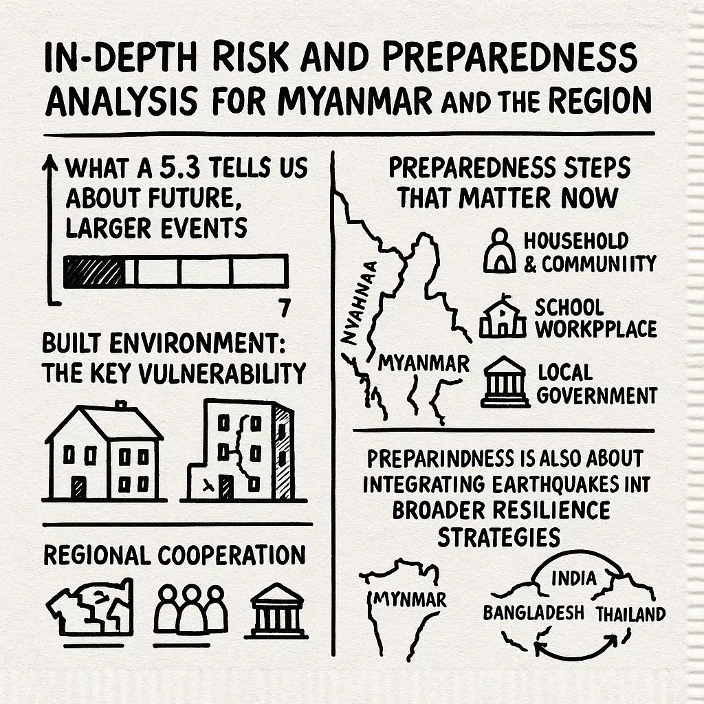
For policymakers, each non-catastrophic event is a chance to learn and adjust without the overwhelming pressure that follows a major disaster. The November 23 earthquake can be used as a reference point to ask practical questions: Did early warnings reach local officials quickly enough? Were hospitals and emergency services clear on their roles? Did schools and workplaces have basic guidelines to follow? Honest answers can drive incremental reforms that, over time, make the system more robust.
Preparedness is also about integrating earthquakes into broader resilience strategies. Many of the same communities facing seismic risk also face floods, cyclones, and landslides. Strengthening building standards, improving land-use planning, and investing in community awareness can reduce vulnerability to several hazards at once. In that sense, using this moderate quake as a catalyst for action is not just about future earthquakes; it is about making everyday life safer in a region exposed to multiple natural threats.
Built Environment: The Key Vulnerability
Moderate events such as the November 23 offshore quake rarely cause devastation by themselves. The real risk emerges when:
- A larger event strikes close to or beneath a major city.
- Buildings and infrastructure were not designed or retrofitted to withstand significant shaking.
In Myanmar, as in Bangladesh and parts of India, many structures:
- Were built before modern seismic codes or in the absence of stringent enforcement.
- Use unreinforced masonry, poorly confined concrete, or irregular designs that perform badly in earthquakes.
- Have undergone informal vertical expansions—extra stories added above original designs—without corresponding strengthening.
The M7.7 Mandalay earthquake in March 2025 exposed these vulnerabilities dramatically, with widespread collapses, severe casualties, and long-lasting disruption.
What a 5.3 Tells Us About Future, Larger Events
A single M5.3 event does not necessarily “announce” a larger quake. However, its occurrence in a known plate-boundary setting carries several implications:
- It confirms that stress is actively accumulating and being released along and near the Burma Plate boundaries.
- It underscores that structures in Myanmar and neighboring countries will face more shaking in the future, including from larger events.
- It provides fresh data to refine hazard models, such as ground-motion prediction equations tuned to Myanmar’s geology.
Seismologists often analyze sequences of small and moderate events to better understand which segments of faults are active, how stress may be redistributed, and where “seismic gaps”—sections that have not ruptured in a long time—might exist.
Preparedness Steps That Matter Now
In light of Sunday’s quake and the broader pattern of regional earthquakes, specialists emphasize several practical steps that can be taken immediately, even before major engineering upgrades are possible:
- Household and Community Preparedness
- Secure heavy furniture, water tanks, and shelves.
- Keep exit routes clear of clutter in homes and workplaces.
- Practice simple “Drop, Cover, and Hold On” drills with family members and co-workers.
- Secure heavy furniture, water tanks, and shelves.
- School and Workplace Drills
- Regular evacuation and shelter-in-place exercises can reduce panic.
- Clear signage for emergency exits and assembly points helps manage crowds.
- Regular evacuation and shelter-in-place exercises can reduce panic.
- Local Government Actions
- Conduct rapid visual screenings of critical buildings—hospitals, schools, bridges—to identify obviously unsafe structures.
- Integrate earthquake scenarios into disaster response plans that also cover cyclones, floods, and landslides, common in the region.
- Conduct rapid visual screenings of critical buildings—hospitals, schools, bridges—to identify obviously unsafe structures.
- Regional Cooperation
- Share real-time data between Myanmar, Thailand, Bangladesh, and India on seismic events and ground shaking.
- Coordinate early-warning and public-information systems to avoid conflicting messages across borders.
- Share real-time data between Myanmar, Thailand, Bangladesh, and India on seismic events and ground shaking.
The November 23 M5.3 earthquake, although not destructive, is a reminder that every moderate event is a rehearsal—for governments, communities, and individuals—to prepare for the day when a much larger rupture occurs along the Burma Plate boundaries.
What the November 23 Quake Means Going Forward
Looking ahead, the November 23 offshore earthquake should be seen as a reminder rather than a conclusion. It confirms that the region’s plate boundaries are active, that moderate tremors can be felt over wide areas, and that existing systems for monitoring and response can function without major disruption. But it does not mean that the hazard has been “released” or that the risk has somehow diminished. The underlying tectonic forces remain in place, and larger events remain possible.
For communities, the most constructive response is to treat this episode as a timely warning to strengthen what can be strengthened now—homes, public buildings, emergency plans, and everyday awareness. If these steps are taken seriously during quieter moments, then when a more powerful earthquake eventually strikes, fewer people will be caught unprepared, and fewer lives and livelihoods will be lost.
A Moderate Event in an Active Year
The offshore magnitude 5.3 earthquake near Myanmar’s coast on November 23, 2025 fits within a broader pattern of seismic activity in and around the Burma Plate. In the same year, the region has seen:
- The M7.7 Mandalay earthquake in March, one of the most damaging events in Asia in recent decades.
- The M5.5–5.7 Bangladesh quake on November 21, which shook the capital Dhaka and exposed urban vulnerabilities there.
In that context, Sunday’s M5.3 is not a catastrophe, but it is an important data point and a reminder that the region is far from quiet tectonically.
No Immediate Cause for Panic, Strong Reasons for Preparedness
From the information available so far:
- There is no indication that the November 23 event has triggered a crisis such as a tsunami or widespread structural damage.
- There is no specific evidence that it heralds an imminent, larger earthquake in the exact same location.
- However, given the long-term behavior of the India–Burma–Sunda tectonic system, stronger earthquakes will happen again somewhere in the region; the only unknowns are when and where.
The realistic and responsible conclusion is clear:
- Calm, informed vigilance is warranted.
- Investing in building safety, public education, and emergency planning will save lives when the next major event strikes.
- Each moderate tremor, like this M5.3 near Myanmar, should be treated as a prompt to strengthen resilience, not as a momentary scare to be forgotten when the ground stops shaking.
In summary
The magnitude 5.3 earthquake off Myanmar’s coast on November 23, 2025, is a moderate offshore event with no reported casualties or significant damage. Yet, it is also part of a larger, ongoing seismic story shaped by the Burma Plate and its adjacent boundaries with the Indian and Sunda Plates. Understanding that deeper tectonic context—and acting on it through preparedness and better construction—is essential if Myanmar and its neighbors are to reduce the human toll of the much larger earthquakes that this region is capable of producing.