
A powerful atmospheric river is drenching the U.S. Pacific Northwest this week, prompting widespread flood watches and warnings as several days of heavy rain, high snow levels and strong winds sweep across Washington and Oregon. Forecasters warn that saturated ground, rising rivers and additional storms will keep flood risks elevated through at least Friday.
Storm overview: who, what, when, where
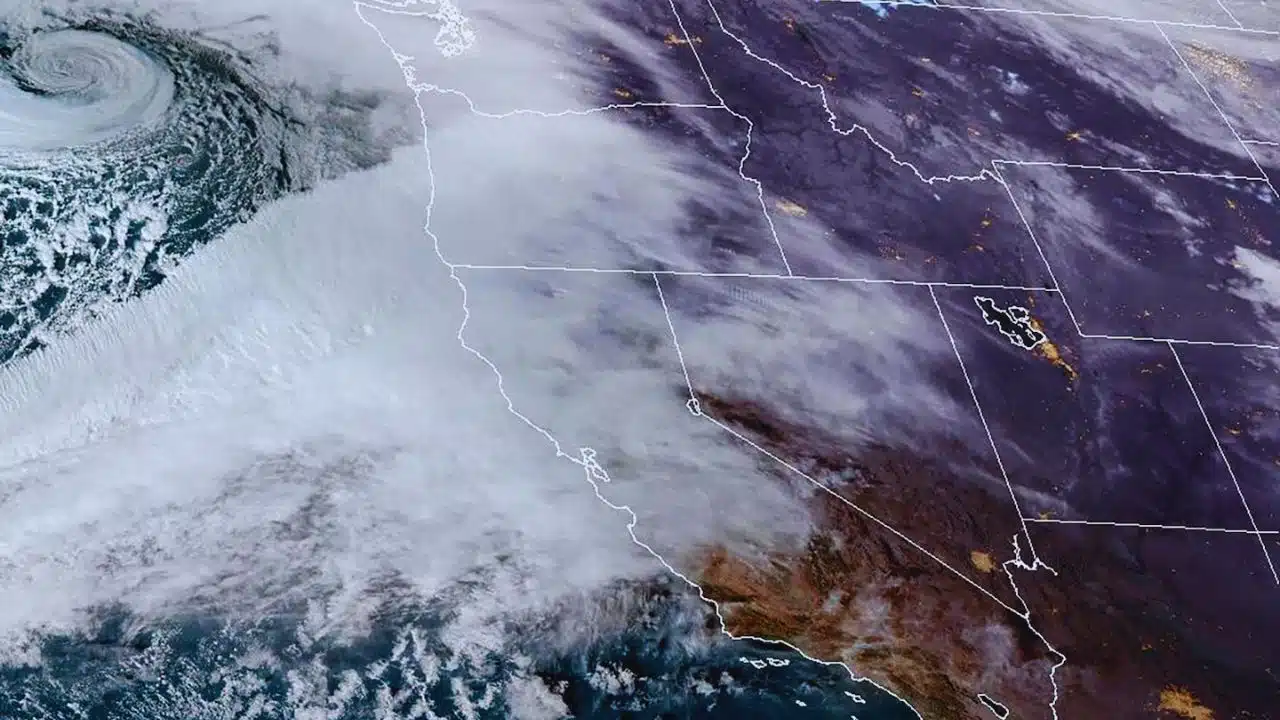
Meteorologists say a strong, long‑track atmospheric river – a narrow band of deep tropical moisture stretching roughly 7,000 miles from near the Philippines – began pushing into the Pacific Northwest on Monday and will linger through mid‑week. The system is focused on western Washington and western Oregon, including the Seattle and Portland metro areas, but moisture and snow are also spreading into the Cascades, Coast Range and parts of Idaho and Montana.
The Center for Western Weather and Water Extremes (CW3E) has rated the primary atmospheric river a level 4 out of 5, indicating a prolonged, high‑impact event capable of producing both beneficial water supply and damaging floods. The National Weather Service (NWS) has issued flood watches and warnings across low‑lying and river‑adjacent communities, while coastal zones and mountain passes face additional threats from strong winds, landslides and heavy mountain precipitation.
Flood threats and expected rainfall
Forecasts suggest that coastal areas and the windward slopes of the Coast Range and Cascades will absorb the brunt of the rainfall, with multiple pulses of moisture moving ashore through Wednesday. The Weather Prediction Center and other forecasters project several inches of rain for many populated valleys, with localized totals that could exceed a foot of rain in favored mountain areas by the end of the week.
Because this is a relatively warm storm, snow levels are expected to remain high early in the event, meaning much of the precipitation will fall as rain even at mid‑elevations and run rapidly into rivers and streams. Hydrologists at the Northwest River Forecast Center warn that repeated heavy rain on already wet ground will drive sharp river rises and potentially push some rivers into moderate or major flood stage, especially in western Washington and northwest Oregon.
Approximate forecast rainfall and flood concern (through late week)
| Area / Region | Forecast rain (through Thu–Fri) | Flood concern notes |
| Seattle metro & central Puget Sound | 3–6 inches of rain | Urban, small‑stream and river flooding possible on local rivers. |
| Portland metro & Willamette Valley | 3–5 inches of rain | Street flooding and river rises; flood watch in effect. |
| Oregon & Washington Coast Range | 6–10+ inches of rain | High risk of landslides, debris flows and rapid river flooding. |
| Washington Cascades (west slopes) | 10–15+ inches rain equivalent, some snow at highest peaks | Major flood threat on rivers draining the Cascades. |
| Southwest Washington & NW Oregon rivers | Several feet of river level rise on key basins | Potential for moderate to major flooding mid‑week. |
how the atmospheric river is unfolding
Forecasts describe at least two main “waves” within the broader atmospheric river event, followed by additional storms that could prolong impacts into next week. The first, strongest pulse began late Sunday into Monday, with intense rain rates near 2.5 centimeters per hour in some coastal and upslope areas, along with gusty winds capable of bringing down tree limbs and power lines.
A second, somewhat weaker but still significant surge of moisture is expected Tuesday into Wednesday, falling onto saturated soils and elevated rivers, which increases the odds that flooding issues will worsen even if rain rates are slightly lower. By Thursday, the atmospheric river is forecast to weaken and shift, but residual showers and runoff moving through river systems mean that peak river flooding may not occur until late in the week or the weekend.
Key timeline of the event (local time)
| Day / Period | Main weather features |
| Monday | Strong first pulse of atmospheric river; heavy rain, 30–40 mph gusts, rapid river rises begin. |
| Tuesday | Continued widespread rain; flood watches expanded; landslide risk grows on steep slopes. |
| Wednesday | Second moisture surge; many rivers approaching or exceeding flood stage. |
| Thursday | Atmospheric river weakens; lighter but persistent showers; river levels may peak. |
| Late week / weekend | Additional storms possible; snow levels may gradually fall, shifting some risk to mountain snow and avalanches. |
Impacts, safety guidance and what comes next
Authorities across the region are warning residents to prepare for flooded roads, possible evacuations in flood‑prone neighborhoods, and intermittent power outages from wind and saturated soils that can topple trees. Transportation officials say mountain passes and key highway corridors could face closures or delays due to water over the roadway, debris, or heavy wet snow at the highest elevations.
Emergency managers and the NWS urge people not to drive through flooded roads, to monitor local alerts, and to be ready to move quickly if evacuation orders are issued near fast‑responding rivers or landslide‑prone hillsides. With climate patterns favoring a wet start to winter and additional atmospheric rivers possible later in December, communities are being told to treat this week’s storm as a reminder of the growing flood and landslide risks along the Pacific coast in a warming climate.