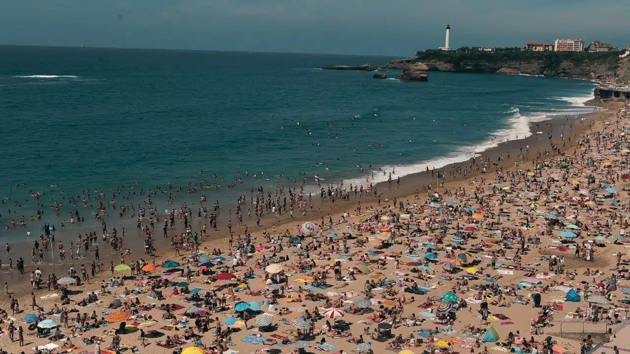
South Korea is currently experiencing one of the most intense and prolonged heatwaves in its history, with temperatures surpassing 40°C in several areas. On July 27, the city of Anseong in Gyeonggi Province recorded a temperature of 40.6°C (105.1°F)—the highest ever measured in the country since modern recordkeeping began. This historic milestone signals not only an alarming development in Korea’s climate trajectory but also a warning of future extremes.
This week, Seoul is forecasted to reach 40°C for the first time ever, while the rest of the country continues to face dangerously high daytime temperatures and stifling nights. Tropical nights, when temperatures remain above 25°C (77°F) throughout the night, have become widespread, leaving people with little chance to recover from daytime heat stress.
What’s Behind This Extreme Heat? A Rare Convergence of Weather Systems
The Korea Meteorological Administration (KMA) has attributed the abnormal temperatures to the overlap of two powerful high-pressure systems—the Tibetan High and the North Pacific High. While either system alone can cause hot weather during Korea’s summer season, their combined presence over the Korean Peninsula has trapped warm air, prevented cloud formation, and amplified solar heating. This configuration, referred to by meteorologists as a “double high-pressure system,” acts like a heat dome, blanketing the region with intense warmth and little atmospheric movement.
Additionally, strong trade winds, as they pass over mountain ranges such as the Taebaek and Sobaek Mountains, become even hotter and drier through a meteorological process known as the foehn effect. As these winds descend on the western side of the mountains, they compress and heat up rapidly, further elevating temperatures in lowland areas.
Unlike typical summer conditions when these high-pressure systems may alternate in dominance or offer temporary relief, this year’s pattern has been unusually stationary and persistent, leaving little room for cooling.
Earlier Onset and Longer Duration Than Past Heatwaves
Experts note that the current heatwave bears striking similarities to the one experienced in 2018, when South Korea also faced record-breaking temperatures. At that time, Seoul reached 39.6°C, its highest temperature until now. However, this year’s event is more extreme in several ways.
In 2024, the overlapping high-pressure systems began forming in early July, weeks earlier than usual. Typically, such configurations peak from late July through mid-August, but this year, the systems intensified sooner and have remained firmly in place for a prolonged period.
As a result, several early summer temperature records have already been broken in cities including Seoul, Daejeon, and Cheongju, and forecasters warn that additional records are likely to fall in the coming days.
Public Health Impact: Alarming Rise in Heat-Related Illnesses and Deaths
The heatwave has had an immediate and severe impact on public health, particularly among vulnerable populations such as the elderly, outdoor laborers, and individuals with chronic health conditions.
According to data released by the Korea Disease Control and Prevention Agency (KDCA), a total of 2,311 cases of heat-related illness were reported between May 20 and July 26—a dramatic rise compared to previous years. This figure marks the highest number of heat illness cases recorded since the agency began collecting such data in 2011.
The human toll has also grown more deadly. Eleven people have died from heat-related causes during the same period, nearly three times more than the four deaths recorded during the same time last year. Most cases involve heatstroke, dehydration, and complications from cardiovascular stress, conditions that become more likely when nighttime temperatures stay elevated and the body has no time to cool down.
Monster Downpours Gave Temporary Relief—But Worsened Humidity
Unusually, the heatwave has occurred in two distinct waves—one in early July and the second starting in late July, shortly after a period of intense rainfall.
Between July 16 and July 20, South Korea experienced heavy downpours, with large rain clouds forming as a result of accumulated moisture and unstable air. These brief episodes provided temporary relief from the heat, particularly in central and southern regions.
However, the rain also left the soil saturated, and when the low-pressure systems responsible for the storms moved away, the Tibetan and North Pacific Highs quickly reasserted themselves. The lingering ground moisture increased humidity levels, which in turn raised the “feels-like” temperatures, worsening discomfort and health risks.
This sequence of heavy rains followed by a quick return to extreme heat created two peaks of dangerous weather conditions in a single month—an increasingly common feature of climate-influenced weather.
Nighttime Conditions Offer No Relief: The Spread of Tropical Nights
In many regions, the heat does not end with sunset. South Korea has seen an increase in tropical nights, where overnight temperatures fail to dip below 25°C (77°F). These tropical conditions disrupt sleep, increase the risk of heart strain, and limit the body’s ability to recover from the heat.
Without cooler nighttime temperatures, urban residents living in high-rise buildings without adequate air conditioning are particularly vulnerable. Hospitals have reported a rise in heat exhaustion, fatigue, and respiratory distress.
Winds from the Southeast Add More Heat to the West
The KMA has indicated that the situation may worsen due to a continued flow of hot, dry southeastern winds, especially as they cross the Taebaek Mountain Range. As the air descends, it becomes compressed, dry, and hotter, contributing to an increase in temperature, especially in the central and western regions of the country.
Combined with clear skies and strong sunlight, this weather pattern traps heat near the surface, raising both daytime and nighttime temperatures. The impact is already visible in cities like Daejeon, Jeonju, and Cheonan, where weather stations have recorded multiple days above 37°C.
Watching the Skies: Typhoon Activity Could Shift the Pattern
One critical variable in the coming weeks will be the behavior of typhoons and tropical depressions forming to the south of the Korean Peninsula. Historically, typhoons can play either a cooling or intensifying role in heatwaves depending on their path and interaction with regional pressure systems.
In 2018, the hottest day on record for South Korea occurred under similar conditions—a double high-pressure system and strong trade winds. At the time, Typhoon Jongdari had weakened near Japan, while a tropical depression carried warm air toward Korea. That tropical system failed to bring cooling rain but instead helped sustain the heatwave.
If a typhoon moves across Korea, it could break the high-pressure pattern, bringing rain and wind to cool the surface. However, if a system dissipates early or veers off course, it could leave the heat dome intact, worsening the conditions.
Government Response and Safety Measures
In response to the escalating threat, the Ministry of the Interior and Safety raised the national heatwave alert to “severe” on July 25, earlier than in previous years. The highest alert level mobilizes local governments to open emergency cooling centers, distribute water and fans, and advise residents to avoid outdoor activities during the hottest hours of the day.
Public health agencies are working closely with the KDCA to monitor hospitals for heatstroke and dehydration cases, while the KMA continues to issue real-time weather bulletins and heatwave warnings via television, radio, and mobile alerts.
Outdoor labor guidelines are being revised to limit work hours and require shade and hydration breaks, particularly for construction workers and farmers who are most exposed to the sun.
Forecast: Heatwave to Persist Until at Least August 6
The KMA’s extended forecast shows little relief in sight. Through at least August 6, temperatures are expected to remain well above average across the country. Daytime highs are projected to stay between 32°C and 37°C, while overnight lows will range from 21°C to 28°C, continuing the trend of tropical nights.
Rainfall is unlikely, and wind patterns suggest that the double high-pressure system will remain dominant, keeping conditions oppressive throughout early August.
A Glimpse into Korea’s Climate Future?
This year’s heatwave is not just an isolated incident—it may represent a climate-driven shift in Korea’s summer weather. According to the World Meteorological Organization and IPCC reports, East Asia is increasingly vulnerable to longer, more intense, and more frequent heatwaves due to global warming and changing oceanic patterns.
Unless aggressive action is taken to curb emissions, restructure urban environments, and improve public health infrastructure, such extreme heat events could become regular features of the Korean summer, posing long-term challenges for both the government and the public.