For generations, the image of Australian farming has been defined by the stockman, the kelpie, and the motorbike. It is a romantic picture rooted in hard work and vast distances. Today, that stockman is still there, but he is just as likely to be looking at a tablet as at the horizon.
Livestock Tracking Technology in Australia has moved quickly from “nice to have” to a daily operational tool. When a single cattle station can cover hundreds of thousands of hectares, knowing where animals are—without burning fuel or hiring a chopper—changes everything.
This shift is not only about convenience. It directly improves efficiency, animal welfare, and biosecurity in an industry under constant pressure to do more with less.
The Role of Livestock Tracking Technology in Modern Australian Farms
Australia was a pioneer in livestock traceability with the National Livestock Identification System (NLIS). NLIS uses RFID ear tags, and it remains essential for legal traceability and sale movements. However, it is a passive system.
You only know where an animal is when it walks past a scanner in a crush, at the yards, or through a saleyard. That tells you where the animal was, not where it is.
Modern tracking changes the dynamic. “Active” smart tags now communicate via satellites or on-farm networks to provide near real-time data. Depending on the device, you can track location, movement speed, grazing patterns, and even body temperature. For large properties, that visibility solves one of the biggest operational gaps: finding animals fast and acting early.
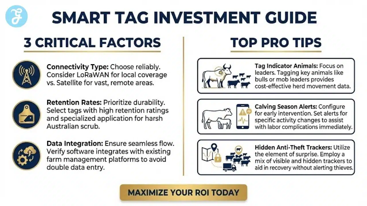
Pro Tip: Start by tagging only your “indicator” animals, such as bulls or the leaders of a mob. Their movements often reflect the location of the wider herd, letting you learn without paying to tag every beast.
3 Things to Consider Before Investing
Before outfitting a herd with smart tags, evaluate these three factors to protect your return on investment.
- Connectivity type: Does your station have reliable LoRaWAN coverage from local gateways, or do you need direct-to-satellite tags? Satellite works almost anywhere but often costs more. LoRaWAN may require upfront infrastructure but can be cheaper to run at scale.
- Retention rates: The Australian scrub is harsh. Look for tags with strong retention ratings and quality application pins. A lost tag is lost data and lost capital.
- Data integration: Data must land somewhere useful. Ensure the platform integrates with your farm management software (for example, AgriWebb or MAID) so you do not double your data entry workload.
Choosing the Right Devices: Ear Tags vs Collars vs Boluses
Livestock tracking technology in Australia usually comes down to three form factors. The right option depends on species, terrain, handling frequency, and how rough your country is on hardware.
First, decide whether you need location only or location plus health and behavior signals. That choice drives costs, battery strategy, and the type of device you can realistically manage.
| Device type | Best for | Strengths | Watch-outs | Typical fit |
| GPS ear tags | Broadacre cattle operations | Familiar application, scalable, good mob visibility | Retention in scrub, antenna exposure, ping/battery trade-offs | Cattle (some sheep variants) |
| GPS collars | Intensive data + virtual fencing | Strong boundary control, more sensors, and often better GPS performance | Higher cost, snag risk in heavy timber, usually for selected mobs | Cattle (virtual fencing), dairy, trials |
| Ruminal bolus | Health and temperature monitoring | Protected inside the animal, consistent readings | Limited theft deterrence, often paired with other ID systems | High-value breeders, health programs |
Use this shortlist before you buy:
- Retention and warranty: retention pin design, breakaway logic (collars), and what the warranty actually covers.
- Ping flexibility: the ability to change update frequency by season (mustering versus wet season).
- Offline behavior: whether the device stores data and backfills when it reconnects.
- Support and replacements: spares availability, turnaround times, and local training.
Beyond the Head Count: The Evolution of Tracking
The first wave of “tracking” focused on identification. The next wave focuses on management.
Active tags flip the model from “scan to know” to “know so you can act.” Instead of learning an animal’s location during the next handling event, you can see where the mob is today and how it is behaving.
That behavior layer matters. A GPS dot on a map helps you find stock. Behavior patterns help you spot risk, catch illness early, and improve grazing decisions across a whole season.
Boosting Efficiency and Reducing Mustering Costs
The fastest financial impact often appears during the muster.
Mustering in the outback can involve helicopters, planes, buggies, and weeks of labor. If the stock is hard to find, fuel costs alone can chew through margins. When you combine aviation, wages, vehicle wear, and delays, the real cost is bigger than most producers want to admit.
With GPS tracking, a grazier can check mob locations on a digital map before any vehicle leaves the shed. This enables “precision mustering.” Instead of sweeping empty paddocks, the team goes straight to the mob. It saves aviation fuel, reduces labor hours, and cuts stress on animals because they are not chased for hours in the heat.
Pro Tip: Use “straggler” data to identify animals that consistently separate from the mob. These are often harder to manage and can become candidates for culling to improve herd behavior.
Animal Welfare and Health Monitoring
Location is valuable, but behavior data can be even more useful.
Algorithms can analyze movement patterns to infer health. A healthy animal follows a predictable routine of grazing, ruminating, drinking, and resting. When an animal gets sick, that pattern changes. It may stop moving, isolate itself, or spend too much time lying down.
Smart tags flag these anomalies and send alerts. Instead of finding a carcass weeks later, you can drive to the GPS point and assess the animal while treatment is still possible. This improves welfare and protects production.
Pro Tip: Configure alerts for calving season. High activity followed by long inactivity can indicate labor complications, allowing you to check a cow quickly.
What Data Actually Moves the Needle (and What’s Just Noise)
Dashboards can overwhelm a busy station. If you want livestock tracking technology in Australia to pay off, focus on signals that change decisions in the paddock.
Start with a short list of high-value indicators and build trust in the system. Once the crew sees that alerts lead to real outcomes, you can expand to deeper analytics.
High-value signals to prioritize:
- Location clusters: where mobs camp, where they avoid, and how this shifts after rain or supplementation.
- Movement outliers: animals consistently lagging (possible illness, injury, or temperament issues).
- Boundary pressure (virtual fencing): repeated cues can signal feed scarcity, water placement problems, or a cell that is too tight.
- Calving risk patterns: sudden activity spikes followed by long inactivity can trigger a targeted check.
Set alert rules that match your real capacity:
- Tier 1 (act today): no movement beyond your threshold, boundary breach at odd hours, calving-risk pattern.
- Tier 2 (act within 3–7 days): repeated straggling, abnormal grazing/rest ratio, frequent boundary cues.
- Tier 3 (trend only): seasonal movement baselines, long-term water-point preferences, and pasture utilization shifts.
| Alert | What it might mean | Best response |
| Stationary for X hours | injury, bogged, calving complication, tag dropped | check last GPS point; confirm ID; retrieve tag if it’s sitting alone |
| Repeated separation | temperament, poor health, predation risk | yard at next handling; assess condition; consider cull or segregation |
| Night-time boundary breach | theft risk or spooked herd | verify speed and direction; escalate if movement suggests transport |
Virtual Fencing: The Holy Grail of Grazing Management
Virtual fencing reduces the need for physical barbed wire. Animals wear a GPS collar or device that plays an audio cue when they approach a virtual boundary set on a tablet. If they continue, they receive a mild pulse.
In the Australian context, where maintaining thousands of kilometers of fencing means constant repairs after rust, floods, and fallen timber, this can be a major step forward. It allows dynamic grazing cells and faster mob moves without rebuilding fence lines.
This unlocks rotational grazing at a scale that many broadacre producers struggled to implement. Better rotations can improve pasture utilization, reduce overgrazing, and support land sustainability when managed well.
Pro Tip: Use virtual fencing to exclude cattle from riparian zones during wet seasons to prevent erosion, then open those areas once the ground is stable.
Improving Biosecurity and Provenance
Biosecurity is a constant concern for Australian agriculture. In an outbreak scenario, authorities and producers need to know where animals have been and which mobs they have mixed with.
Digital tracking creates a data trail. If an animal tests positive, you can trace movements and contacts to support targeted quarantines rather than broad shutdowns. That matters for containment and for business continuity.
The same data also supports marketing and provenance. Many buyers want the story behind their food. Verified movement histories, grazing patterns, and paddock timelines can add credibility to claims like “grass-fed” and “free roaming,” which may help secure a premium in certain markets.
Pro Tip: Use tracking reports to verify grass-fed claims by exporting paddock residence time. Concrete data helps in buyer conversations and audits.
![]()
Overcoming the Connectivity Challenge
Connectivity is often the biggest barrier. A smart tag is useless if it cannot send data back to the dashboard.
Australia has large “black spots,” and many properties will never see reliable 4G coverage across their whole footprint. The landscape is improving through two common approaches:
- Direct-to-satellite tags: devices that upload data via satellite, reducing the need for local towers.
- LoRaWAN gateways: a private long-range network where a tower on a high point can connect devices within roughly 10–15 km, depending on terrain and line-of-sight.
Pro Tip: If you use LoRaWAN, mount the gateway at the highest practical point with reliable solar power. Line-of-sight has a huge impact on range.
A Practical ROI Snapshot: Where the Payback Usually Comes From
The ROI story is usually about savings and avoided losses. Track what matters and keep the model simple so the team trusts it.
| ROI lever | What you measure | How tracking helps | Notes |
| Mustering efficiency | hours, fuel, aviation time | go straight to the mob; reduce sweeps | biggest win on large, remote country |
| Labour reduction | staff days per month | fewer search trips and checks | also reduces vehicle wear |
| Calving performance | calves weaned vs expected | earlier intervention on alerts | Small percentage lifts can be significant |
| Mortality and welfare | deaths found late vs early | quicker treatment and recovery | value depends on terrain and pressure |
| Theft deterrence | incidents per year | boundary alarms and tracking | best with good gate discipline |
A fast payback estimate:
- Add annual mustering and search costs (fuel, labor days, aviation, contractor time).
- Use a conservative saving assumption (start at 5–15%).
- Add potential gains from improved calving outcomes.
- Subtract device costs, subscriptions, and gateway costs (if used).
- Run a small pilot first. Scale only after the numbers show up in your own conditions.
Theft Prevention
Stock theft, or “duffing,” remains a serious problem in rural Australia. With high meat prices, livestock can become a tempting target. Traditional ear tags can be removed quickly, and once animals are on a truck, they can disappear fast.
GPS tags create deterrence and support recovery. Many systems allow geo-fences around property boundaries. If an animal crosses a boundary at unusual hours, an alarm triggers. If the animal then moves at transport speeds, that can indicate it is on a vehicle.
Pro Tip: Do not advertise which animals have trackers. Visible devices can deter theft, but “hidden” trackers in a mob can help track a truck without the thieves realizing.
Implementation Plan That Actually Sticks (Without Overloading the Crew)
Tech fails when it creates admin. To make livestock tracking technology in Australia part of normal station life, treat it like a process change with clear ownership and simple routines.
Phase 1: A 30–60 day pilot
Pick one mob and one purpose, such as mustering efficiency or calving alerts. Define success in plain terms, and set one simple check habit.
- Choose indicators (leaders, bulls, bellwethers).
- Set Tier 1 alerts only.
- Log each alert and the action taken.
Phase 2: Standardise workflows
Write a one-page SOP so everyone handles tags and alerts the same way.
Include:
- how devices are applied and checked
- how alerts are acknowledged and escalated
- what “false alarms” look like (for example, a dropped tag)
Assign clear roles:
- Data owner: IDs, mob lists, and integration accuracy
- Ops owner: takes action, records outcomes, and closes the loop
Phase 3: Scale with the seasons
Expand before the season when the benefit is highest. Adjust ping rates to protect battery life and reduce noise.
| Common rollout mistake | Why it hurts | Fix |
| Tagging everything at once | overwhelms staff and creates messy data | scale by mob and clean IDs first |
| Too many alerts | people stop trusting the system | begin with Tier 1 only |
| No close-the-loop step | alerts don’t change outcomes | record the action and result |
| Skipping training | inconsistent use across crews | short monthly toolbox refresh |
The Digital Paddock: What Comes Next
The adoption of livestock tracking technology in Australia is no longer a question of if, but when. Savings from fuel and labor, better calving outcomes, and reduced losses make the business case stronger each year.
As device costs fall and satellite coverage expands, the “digital paddock” becomes more practical for more properties. That does not replace the stockman. It equips the stockman with better visibility, faster decisions, and more control across a tough landscape.
Frequently Asked Questions (FAQs)
Here are answers to some of the most common questions:
Costs vary based on features. Basic tags may start around $30–$50 AUD per unit, while satellite-connected tags can range from $100 to $200+ per unit. Many producers start with high-value animals like bulls or breeders and expand once the value is proven.
Yes, depending on the system. Many modern tags use direct-to-satellite connectivity or private LoRaWAN networks, which can operate in remote areas where 4G and 5G do not reach.
Is virtual fencing legal in all Australian states?
Rules can vary by state and may change over time. Check current regulations from your state’s Department of Primary Industries or equivalent authority before deploying virtual fencing systems.
How long do the batteries last on livestock trackers?
Battery life depends on device type and ping frequency. Some solar-assisted ear tags aim for multi-year performance, while battery-only devices may run for several years under conservative settings. More frequent location updates usually reduce battery life.
In most cases, GPS devices are used alongside the mandatory NLIS tag. NLIS remains a legal requirement for traceability and sale movements. Some products may be accredited to serve as both tracking and official identification, but you should encourage checking compliance and accreditation before relying on one device.
What happens if the tag falls out?
Retention is a major focus for manufacturers. If a tag falls out, the GPS may show it staying stationary in one spot. You can then retrieve the device and reapply it, protecting the hardware investment and restoring your data stream.
How many animals should I tag to start seeing results?
Start with 5–15% of the mob, focusing on indicator animals (bulls, lead cows). That’s usually enough to locate the herd and spot outliers, and then you can scale up if the ROI is clear.