
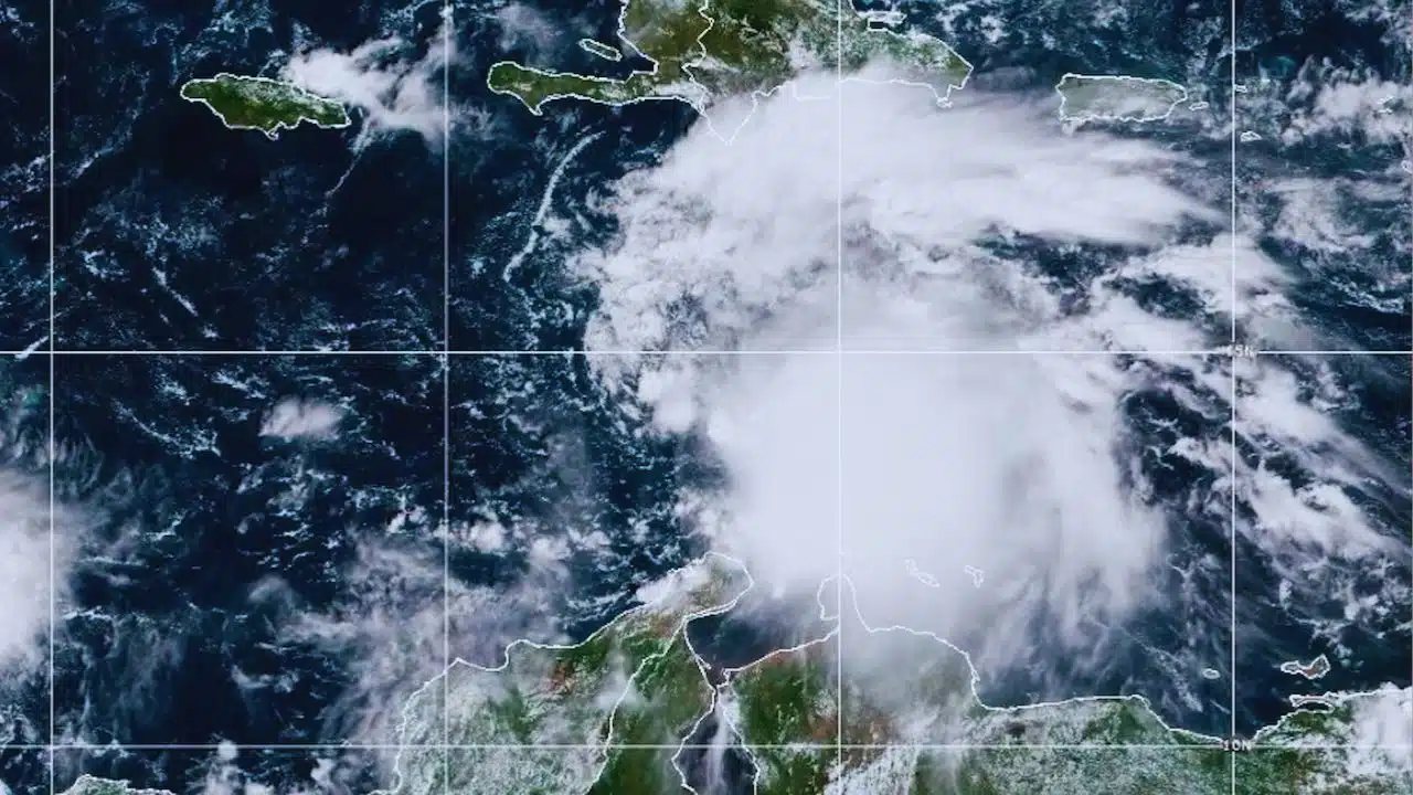
The island of Jamaica is bracing for a catastrophic, direct impact as Hurricane Melissa stalled and explosively intensified into a major Category 4 storm overnight, now churning just south of the island with devastating 140 mph winds. Landfall is expected within the next 24 to 36 hours, threatening the nation with its most powerful storm in decades.
Prime Minister Andrew Holness has placed the nation on high alert, urging citizens in low-lying and coastal areas to evacuate immediately. “I urge Jamaicans to take this weather threat seriously,” Holness stated in a national address. “Take all measures to protect yourself.”
The storm, described by forecasters as a “worst-case scenario” due to its slow speed and extreme rainfall potential, is expected to unleash life-threatening flash floods, mudslides, and a devastating storm surge.
Key Facts: Hurricane Melissa (as of Oct 27, 2:00 AM)
- Status: Category 4 Major Hurricane
- Max Sustained Winds: 140 mph (225 kph) with higher gusts.
- Location (approx.): 110-120 miles south-southeast of Kingston, Jamaica.
- Movement: West at 5 mph (7 kph) — a dangerously slow crawl.
- Forecast Rainfall: 15 to 30 inches (760 mm), with isolated totals up to 40 inches (1,010 mm) in mountainous areas.
- Forecast Storm Surge: 9 to 13 feet above normal tide levels expected near and to the east of landfall.
- Warnings: A Hurricane Warning is in full effect for the entire island of Jamaica.
A ‘Rapid Intensification’ Event
What has alarmed meteorologists is Melissa’s “explosive strengthening.” On Saturday, the system was a tropical storm. Fueled by exceptionally warm ocean waters, it rapidly intensified, jumping from a Category 2 to a Category 4 hurricane in less than 24 hours.
This rapid growth, combined with its agonizingly slow 5 mph forward speed, creates a dual threat:
- Destructive Winds: Category 4 winds will cause catastrophic damage to infrastructure, flattening homes, snapping power poles, and rendering areas uninhabitable for weeks.
- Catastrophic Flooding: The slow movement means Melissa will sit over or near Jamaica for an extended period—potentially “for several days,” according to one expert—dumping record-breaking rainfall.
“Conditions (in Jamaica) are going to go down rapidly today,” warned Jamie Rhome, deputy director of the U.S. National Hurricane Center (NHC).
Island on Lockdown: Official Response
The Government of Jamaica has activated its national emergency response mechanism.
- Airports Closed: Both of the island’s international airports, Norman Manley International in Kingston and Sangster International in Montego Bay, were ordered closed by Sunday.
- Shelters Activated: Minister of Local Government Desmond McKenzie confirmed Sunday that 881 emergency shelters have been activated across the island.
- Evacuations: Mandatory evacuation orders are being issued for all low-lying and flood-prone areas, particularly in coastal parishes like Kingston, St. Andrew, St. Thomas, and Clarendon. However, reports from the ground suggest some residents are refusing to leave.
“This is not the time for people to become complacent,” Minister McKenzie stated in a press briefing, emphasizing the extreme danger, particularly for communities in the capital. “Kingston is extremely low. No community in Kingston is immune.”
The Dual Threat: Surge and Mountain Floods
Experts are warning that Jamaica’s unique topography makes it exceptionally vulnerable to a storm like Melissa.
- The Coastal Threat: The NHC is forecasting a “life-threatening storm surge” of 9 to 13 feet. This wall of water will inundate coastal communities, including parts of the capital, Kingston, and historic sites like Port Royal.
- The Inland Threat: Evan Thompson, principal director of the Meteorological Service of Jamaica, stressed that the entire island is at risk. “There is potential (for) flooding in every parish of our country,” Thompson said.
The storm’s moisture will be forced up by Jamaica’s central mountainous spine, creating a deluge scenario. The forecast of 30 to 40 inches of rain will inevitably trigger catastrophic, fast-moving flash floods and widespread mudslides, washing out roads, isolating communities, and threatening lives in hillside settlements. The deep gullies that run through Kingston are expected to become raging, deadly rivers.
‘Father God Will Protect Us’: A Nation Prepares
On the ground, the atmosphere is a mix of frantic preparation and, in some cases, fatalistic resolve. Supermarkets saw a rush for staple items like bread, water, and batteries on Friday and Saturday, and many residents in Kingston and Montego Bay spent Sunday boarding up homes and businesses.
This storm is drawing dire comparisons to Hurricane Gilbert, the devastating Category 3 storm that crossed the entire length of Jamaica in 1988. Gilbert was the last major hurricane to make a direct hit, killing 45 people and causing billions in damage. Melissa, however, is approaching as a stronger storm (Category 4) and, crucially, is moving much slower, portending a far worse rainfall and flooding event.
Despite official pleas, some residents in the most vulnerable areas are refusing to evacuate. In the historic fishing village of Port Royal, which sits on a narrow spit of land at the mouth of Kingston Harbour, residents were seen securing their homes but vowing to stay.
“We know danger and we know when we are in danger and right now we are not,” Ann Marie Chamberlain, 51, told reporters for The Guardian. “Father God will protect us.”
This defiance is a major concern for officials, who say emergency services will not be able to reach those who stay behind once the storm’s core hits.
What to Watch Next
The critical window for Jamaica is Monday (today) through Tuesday. Conditions will deteriorate rapidly through the morning, with tropical-storm-force winds arriving first, followed by the devastating hurricane-force winds and torrential rain this afternoon and into the night.
The center of Hurricane Melissa is forecast to make its closest approach or landfall on the southern coast, likely near or just west of Kingston, late Monday or early Tuesday.
After it passes Jamaica, the storm is forecast to strike eastern Cuba as a major hurricane by late Tuesday, before moving toward the southeastern Bahamas and Turks and Caicos Islands later in the week.
The entire island of Jamaica is now in a race against time, bracing for a storm that could reshape parts of the nation and poses an extreme threat to life and property.