
The India Meteorological Department (IMD) has issued a significant update regarding the developing low-pressure system over the Bay of Bengal, which is expected to intensify into Cyclone Remal.
The cyclone is projected to reach the coasts of West Bengal and Bangladesh by Sunday evening, marking the first pre-monsoon cyclone of the season in the Bay of Bengal.
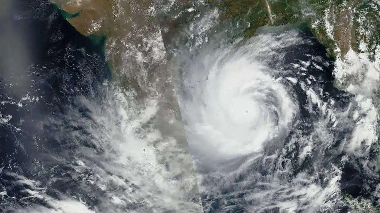
Key Developments and Timeline
According to IMD scientist Monica Sharma, the low-pressure system will concentrate into a depression over the central Bay of Bengal by Friday morning.
This system is expected to further intensify into a cyclonic storm by Saturday morning and reach the coastal regions of Bangladesh and West Bengal as a severe cyclonic storm by Sunday evening.
The cyclone is anticipated to reach wind speeds of up to 102 kilometers per hour on Sunday.
Impact on Coastal Regions
Let’s take a look at how it impacted Coastal Regions.
Weather Warnings
The IMD has issued warnings of very heavy rainfall in the coastal districts of West Bengal, north Odisha, Mizoram, Tripura, and south Manipur on May 26 and 27.
Fishermen have been advised to return to the coast and avoid venturing into the Bay of Bengal until May 27 to ensure their safety.
Fishermen Advisory
Given the expected intensity of Cyclone Remal, the IMD has urged all fishermen currently at sea to return to the coast immediately and refrain from venturing into the Bay of Bengal until the cyclone passes.
Rapid Intensification Due to Warm Sea Temperatures
Scientists have pointed out that cyclonic storms are intensifying more rapidly and retaining their strength longer due to warmer sea surface temperatures.
This warming is attributed to the oceans absorbing most of the excess heat generated by greenhouse gas emissions. The past 30 years have recorded the highest sea surface temperatures since record-keeping began in 1880.
Atmospheric Conditions
Madhavan Rajeevan, former secretary of the Union Ministry of Earth Sciences, noted that a sea surface temperature of 27 degrees Celsius and above is necessary for a low-pressure system to intensify into a cyclone.
Currently, the Bay of Bengal’s sea surface temperature is around 30 degrees Celsius, creating favorable conditions for cyclone formation.
However, Rajeevan highlighted that vertical wind shear, a change in wind speed and direction with altitude, plays a crucial role in determining the cyclone’s intensity.
A large vertical wind shear can weaken a cyclone.
Potential Impact on Monsoon Progress
Senior IMD scientist DS Pai mentioned that initially, the cyclonic system would aid the monsoon’s progress over the Bay of Bengal.
However, as the system detaches from the monsoon circulation and draws in significant moisture, it might slightly delay the monsoon’s progress in the affected areas.
What to Expect
- Increased Rainfall: Coastal regions should prepare for heavy rainfall and potential flooding.
- High Winds: With wind speeds reaching up to 102 km/h, expect strong winds that can cause damage to infrastructure.
- Sea Conditions: Rough sea conditions are anticipated, making it dangerous for marine activities.
- Emergency Preparations: Local authorities and residents should stay informed and be ready to implement emergency measures as necessary.
As Cyclone Remal approaches, the coordinated efforts of meteorologists, government agencies, and local communities will be vital in minimizing the impact and ensuring the safety and well-being of all affected areas.
What’s Next?
Cyclone Remal is poised to make a significant impact on the coastal regions of West Bengal and Bangladesh by Sunday evening.
The IMD’s timely warnings and advisories aim to mitigate the potential damage and ensure public safety. As the situation develops, continuous monitoring and updates will be crucial to manage the cyclone’s effects effectively.
The Information is Taken from Live Mint and NDTV