
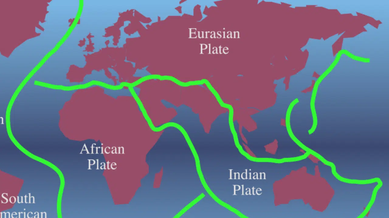
The Himalayas, the tallest mountain range in the world, are formed by the collision of two tectonic plates – the Indian Tectonic Plate and the Eurasian Plate. This constant movement of these plates increases seismic activity in this region along its entire length.
The risk of a massive earthquake hitting this highly active seismically vulnerable region is becoming increasingly greater. Because of climate change and ongoing geological changes, a massive quake could have devastating consequences for people living near it.
This blog post will explore what led to these earthquakes, how we can prepare for them, and what infrastructure would be needed to mitigate their potentially deadly impact. By reading this post, readers will gain an understanding of why catastrophic Himalayan earthquakes occur, as well as insight into steps that can be taken to protect local populations from future disasters.
Content Highlights
- The Himalayas are formed by the convergence of two plates – the Indian and Eurasian Plates – leading to increased seismic activity throughout.
- Climate change is anticipated to increase earthquake frequency in this region, while human activities such as mining and deforestation can also cause earthquakes that have devastating consequences for locals.
- Particular attention must be given to The Main Himalayan Thrust (MHT), located beneath northern India, which has patches with no movement but areas where stress can accumulate over time potentially leading to a massive quake.
- Disaster preparedness plans must be made at various levels as preparedness efforts are key for mitigating risk associated with earthquakes in this seismically active region.
Latest Updates:
Indian and Eurasian Plate Collision
The collision of the Indian Plate and the Eurasian Plate began roughly 50 million years ago, resulting in drastic changes to the region’s geography. This process gave rise to some of the highest mountains in the world — namely, the Himalayas and Tibetan plateau.
The Himalayan range is located at a convergent boundary between these two continental plates. The continued northward drifting of the Indian subcontinent continues despite its crunching against existing obstacles like Eurasia’s plate margin; this movement has made seismicity rampant in this area due to strain beginning to build up over time along fault lines shared by both tectonic plates.
Climate change is anticipated to increase earthquake frequency as warmer temperatures cause more water vapor to be released into rivers feeding from high-altitude glaciers, significantly increasing glacier melt rates and affecting quake activity, while human intervention can also trigger quakes when reservoirs or tunnels get filled with water suddenly exerting pressure on fault lines below them.
How The Himalayas Formed?
The Himalayas are a product of the collision between the Indian Plate and the Eurasian Plate, which began around 50 million years ago and still continues today. Under immense pressure from their ongoing convergence, these plates have pushed against each other forcing rock upward to form this massive mountain range.
The continent-continent collision has broken up the release of extraordinary amounts of strain energy as tectonic forces generated powerful earthquakes across the region. As India moves northwards at an estimated rate of 20 cm annually, it creates horizontal stress along existing faults in various parts of the Himalayan region dramatically increasing its seismic activity.
This ongoing tectonic collision has far-reaching implications for people living in the area as it increases their risk for earthquakes and consequently other disasters like landslides and floods caused by melting glaciers amongst others.
Seismic Activity In The Region
The Himalayan region is one of the most seismically active regions in the world, experiencing frequent moderate to large earthquakes. The tectonic activity that creates this high seismic hazard is mainly caused by transform faults on either side of the Indian Plate.
When two plates collide as they do along the Himalayas, it sends shockwaves through both plates and the surrounding area resulting in fatalities and severe damage to buildings. As a result of continental collisions between India and Eurasia, a tremendous amount of strain has been stored up which increases seismic risk potential for devastating earthquakes at any moment.
Additionally, due to its location on the boundary of these two major tectonic plates, Nepal is particularly prone to quakes compared with other countries within South Asia. Furthermore, special attention must be given to The Main Himalayan Thrust (MHT) located beneath northern India—here there are patches where no movement occurs but also areas where stress can accumulate over time leading to possible future movements eventually leading to catastrophic events such as a massive earthquake like those seen in 2005 Kashmir or 2015 Nepal.
Factors Contributing to Massive Himalayan Earthquakes
Numerous factors, such as the accumulation of strain and energy or super-cycle of earthquakes contribute to the increased risk of a massive Himalayan earthquake – read on to find out more.
Related Articles:
Accumulation of Strain and Energy
Accumulated strain and energy is one of the key factors in the occurrence of massive earthquakes in the Himalayan region. A constant collision between the Indian tectonic plate and the Eurasian plate, caused by continental drift forces that created elevated topography such as the Himalayas, accumulates strain and energy in this zone.
This potential energy is stored within rocks along major fault lines known as thrusts. Notably, the Main Himalayan Thrust (MHT), also referred to as a Reverse Fault, plays a central role in this geological phenomenon.
The initiation of this process is driven by the deformation of rock caused by the stress absorbed from both sides of the fault. Over the years, this stress accumulates, metrically powering up these regions until it surpasses the frictional strength of the rocks. When this threshold is breached, it leads to the release of large-magnitude seismic waves. These seismic events are often accompanied by the occurrence of full-rupture landslides.
In essence, a captivating interplay of geological forces and rock mechanics underpins these regions’ seismic events.
Climate change brings added pressure with fast-paced glacial melting, which puts a higher load on many ranges across the country and increases risk inventory for affected countries like India. Researchers are using advanced geodetic GPS techniques along with seismological making breakthrough contributions towards understanding dynamics associated with building up strains at deeper levels providing detailed insights into the probability of future events and allowing even better preparedness efforts deployed accordingly.
Super-Cycle of Earthquakes
As a result of the meeting of two continental plates, super-cycles of earthquakes occur in the Himalayan region. The Indian plate and Eurasian plate have been pressing against each other for millions of years, with tremendous force creating the Himalayas.
This tension is building up daily along their margins, resulting in seismic activity that has caused devastating quakes throughout history. When the energy trapped by this tension exceeds a certain level, it gets released suddenly via an earthquake, bringing destructiveness on an immense scale.
The accumulation of strain and energy over time is one major factor contributing to these massive earthquakes that characterize super-cyclical quake cycles in the region.
Furthermore, human activities such as mining and deforestation can alter soil structures making them prone during an earthquake leading to a heightened risk for mega disasters like tsunamis or landslides.
Impact of Climate Change and Human Activities

Climate change is rapidly altering the environment of the Himalayan region, which can have serious implications for seismic risks in the region. For example, changes in temperatures and precipitation levels can increase snow-melting rates, which then adds stress to certain faults around the mountains.
Additionally, glaciers are retreating due to warmer temperatures throughout much of the Himalayas further making these earthquakes more likely as meltwater seeps into nearby rocks causing them to move and become destabilized leading to a greater probability of major events.
Furthermore, human activities such as deforestation also contribute a major factor when it comes to earthquake risk – removing forests allows rainwater runoff during monsoons that puts additional pressure on local slopes over time resulting in landslides or weakening particular fault lines even further potentially pre-disposing them towards major seismic activity if triggered than ever before.
Impacts of a Massive Himalayan Earthquake
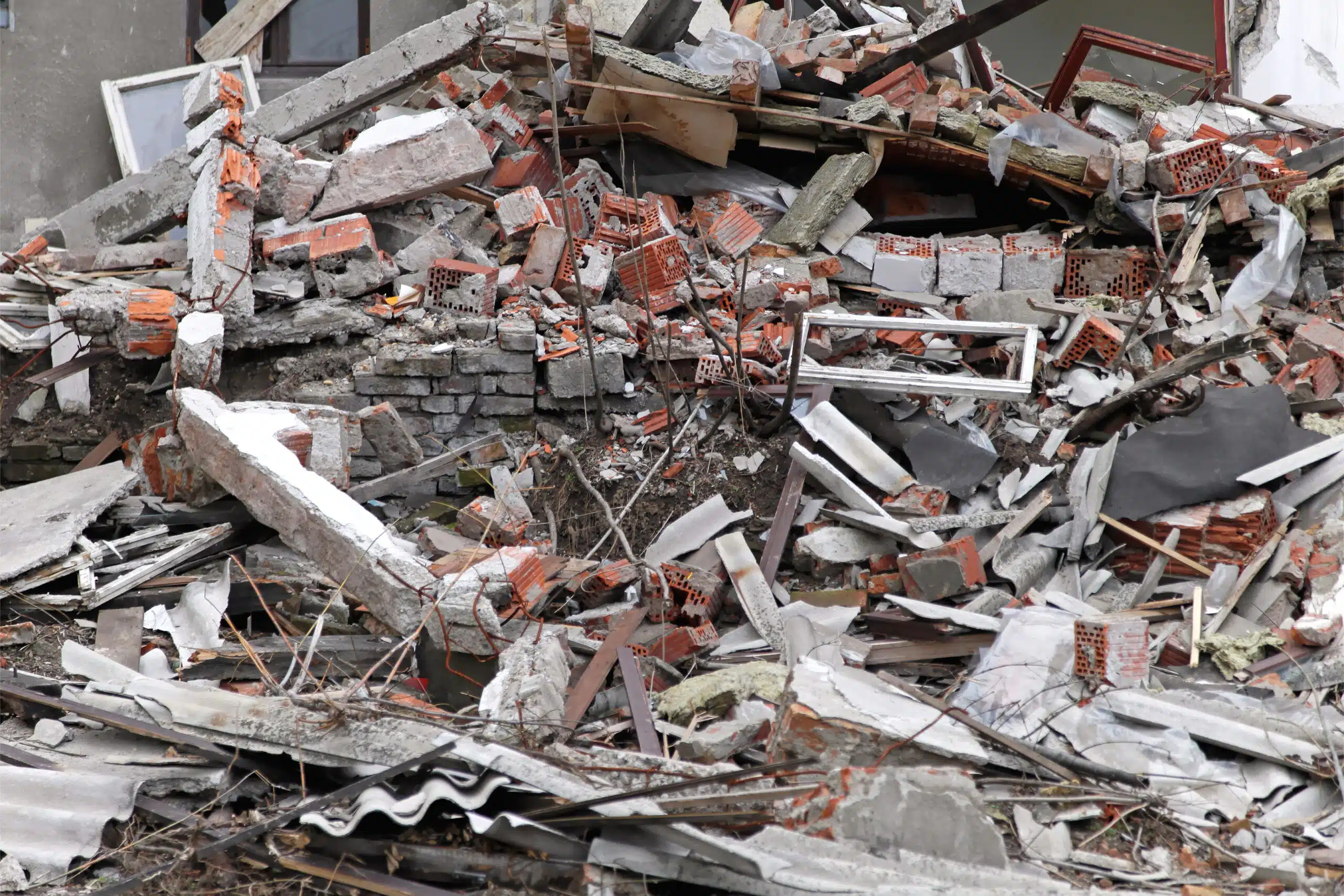
A massive earthquake in the Himalayan region can have devastating consequences, including loss of life and property, disruption of infrastructure and services, as well as environmental degradation.
Loss of Life and Property
The risk of large-scale loss of life and property due to a massive Himalayan earthquake is real. The magnitude 7.8 Nepal earthquake in 2015 caused over 9000 deaths and extensive destruction of buildings, infrastructure, and services.
This devastating quake had long-lasting effects on the region including displacement of vulnerable populations and damage to water supply systems and agricultural land creating major socio-economic challenges that take decades to overcome.
Such an event has far-reaching impacts beyond the immediate losses as it has the potential to worsen poverty levels in already impoverished areas further leading to additional health risks for communities who are already living in precarious environments with limited access to medical care or other essential support systems.
Disruption of Infrastructure and The Economy
A massive Himalayan earthquake could be catastrophic to surrounding communities. The potential destruction of roads, buildings, bridges, and other infrastructure is potentially devastating due to the significant economic costs required for repair or rebuilding.
In addition, areas with more physically vulnerable populations would be disproportionately affected by the loss of essential services such as water supply and power grids as well as communications networks.
Relatively isolated population centers may find themselves particularly disadvantaged for extended periods until access to these services can be established again.
Additionally, losses in productivity may compound the loss of human life and property damage caused by the earthquake. Areas heavily dependent on tourism may face economic hardships. This happens when visitors can no longer travel safely due to safety concerns, resource shortages, or disrupted transportation routes.
After a seismic event, displacement can occur, causing those in the tourism industry to seek opportunities elsewhere. This, in turn, exacerbates the negative impact on local financial growth.
Environmental Consequences
Nepal experienced one of the biggest earthquakes in its history in April 2015 that killed nearly 9,000 people and caused millions of dollars worth of damage to property.
This catastrophic earthquake highlighted the devastating environmental consequences of such seismic events as it led to a degeneration of vegetation, the destruction or loss of wildlife habitat, collapse or flooding due to lake outburst floods and landslides, indirect damage through water pollution, and contamination by hazardous chemicals.
Devastating Earthquakes In The Himalayas: Understanding Earthquake Priming
Seismic activity in the region has caused widespread destruction with past earthquakes, including some of the most devastating in recorded history.
Earthquakes in the Himalayan region occur when two mass plates collide with each other, resulting in a huge amount of energy and tectonic stress being built up across the region. This build-up is known as earthquake priming, where the Earth’s crust stores a great deal of strain until it eventually reaches its limit, leading to an earthquake occurring.
The accumulation of this energy is largely due to continental collision between India and Eurasia which has been happening for about 50 million years, causing immense pressure on both plates and forming mountains such as the Himalayas.
As energy continues to accumulate along these plate margins every year, they become increasingly at risk for seismic activity. Over time, large slabs of brittle rocks are pushed together beyond their natural limits leading to a sudden release of enormous amounts of heat and energy during an earthquake event.
History of Major Earthquakes In The Region
Throughout history, the Himalayas have experienced a number of devastating earthquakes.
In 1950, an 8.6 magnitude earthquake flattened much of Nepal and Tibet; in 1993, a 6.4 magnitude disaster struck Bihar causing widespread destruction; and in 2015, Nepal suffered yet another cataclysmic quake measuring 7.8 on the Richter scale. These are just a few examples of how powerful these seismic events can be when they strike this part of the world.
Here is a table of some of the recorded earthquakes in history due to the Indian Tectonic Plate movements:
|
Date |
Magnitude |
Place of Origin |
Affected Area |
Number of People Injured |
Number of People Died |
|
1819 |
7.8 |
Kutch, India |
Gujarat, India |
Unknown |
1,543 |
|
1905 |
7.8 |
Kangra, India |
Himachal Pradesh, India |
20,000+ |
19,000+ |
|
1950 |
8.6 |
Assam-Tibet |
Assam, India |
Unknown |
1,526 |
|
1993 |
6.4 |
Latur, India |
Maharashtra, India |
30,000+ |
10,000+ |
|
2001 |
7.7 |
Bhuj, India |
Gujarat, India |
166,836 |
20,023 |
|
2005 |
7.6 |
Kashmir, India |
Pakistan, India |
75,266 |
86,000 |
|
2015 |
7.8 |
Nepal |
Nepal, India, China |
22,000+ |
9,000+ |
Potential for a Mega-Disaster
The Himalayan populations are intentionally vulnerable to earthquakes, as they remain in an active seismic zone where the Indian tectonic plate and the Eurasian plate continue to converge.
It is not difficult to imagine a magnitude 8.6 or more earthquake similar to the devastating past quakes that had swept away entire towns back in 1950. Such an event would have catastrophic consequences like major landslides, floods, and more, making millions of people homeless overnight and creating chaos beyond measure.
The risk for such massive earthquakes is made even greater due to climate change. Studies suggest that it may be causing more destructive cause tremors and affecting their frequency too.
To further this point, all data shows that the entire region from Afghanistan through Pakistan India, and Nepal remains highly prone to tremors with a strong possibility of being subjected to a mega-disaster anytime soon. However, this could prove fatal due to infrastructure restraints serving those areas, among other factors like lack of mitigation strategies.
Significance of Himalayan Geodesy
Utilizing historical triangulation and GPS geodesy techniques, understanding Indo-Asian convergence and seismicity becomes key in predicting potential earthquakes in the Himalayas.
Historical Triangulation and GPS Geodesy
Historical Triangulation and GPS geodesy are two geographic mapping techniques used to study the movement and evolution of plate tectonics over time. Historical triangulation studies use the measured angle between three fixed points, or objects on the ground, in order to calculate their location.
The technique is also known as trigonometric surveying or survey triangulation, which has been used for centuries but wasn’t popularized until the 17th century. Astronomer Edmond Halley developed a practical method for its application.
GPS geodesy harnesses satellite-based global positioning systems (GPS) to measure locations with great accuracy by using radio frequency signals sent from multiple satellites orbiting overhead.
By combining both techniques together, researchers are able to observe seismic activity shifts that provide better insight into risks of massive Himalayan earthquakes such as predicted strain accumulation or rupture propagation within certain areas of the Indian Plate’s boundary regions including Pakistan and northwest India.
Understanding Indo-Asian Convergence And Seismicity
Tectonic convergence between the Indian and Eurasian plates is a major force in shaping the Himalayas, as well as generating seismic activity in the region. Over millions of years of collision and compression between the two plates, thrusts from rocks underneath India have been forced upward, giving rise to mountain ranges including the Himalayas.
The immense stress that builds up due to this plate movement can lead to large earthquakes throughout India and Nepal when it is released suddenly along fault lines. This phenomenon has been observed historically.
For example, an earthquake measuring 7.8 on the Richter scale occurred near Kangra Valley in 1905 due to tension at intervals caused by Indian-Eurasian plate boundaries releasing energy violently through ruptures along tectonic plate edges.
The Main Himalayan Thrust (MHT) plays a significant role in seismicity associated with Indo-Asian convergence by creating higher friction points where strain accumulates over time until it results in an earthquake event suspended against interacting layers (decollement).
Implications for the Future
By understanding the Indo-Asian convergence and seismicity, we can shed light on the potential for catastrophic earthquakes in the future. Explore more to uncover how advances in geodesy technology will inform us about this region’s tectonics.
How Earthquakes Rupture and Nucleate?
When earthquakes occur, the pressure that has built up along a fault line is suddenly released. This sudden energy release sends shock waves through the ground, propagating outward from where the rupture began as it accumulates strain and energy over time.
Subsequent nucleation refers to an additional break in different portions of a seismic zone or fault that can cause further hazardous rupturing at multiple locations or depths simultaneously.
In the Himalayas, areas of convergence between two plates—the Indian Plate and the Eurasian Plate—create numerous weak points susceptible to seismic activity which will likely lead to large-scale landslides and violent tremors.
Given its location on a major convergent margin between two continental plates, these subsequent ruptures may be triggered by large primary ruptures happening elsewhere along mega faults like the Main Frontal Thrust Fault (MFTF) or Main Himalaya Thrust Fault (MHTF).
Seismic Gaps and the Potential for Future Earthquakes
Seismic gaps are sections of the Indian Tectonic Plate along the Himalayan Plate Boundary that have not experienced significant earthquakes in the last hundred years, and may present higher potential for a massive earthquake event.
Seismic quiescence is an important variable in evaluating future seismic risk. Regions where strain has been accumulating over geologic time periods due to collision between large tectonic plates (like Indian and Euroasian) with no major release, resulting in a decreased frequency of earthquakes, can be particularly hazardous.
Recent advances made using historical records, seismological data, as well as GPS observations of plate motion support this hypothesis: by preferentially studying these seismic gaps, researchers gained an insightful understanding of Indo-Asian convergence and recent seismicity.
The Role of The Indian Monsoon
The Indian monsoon plays an important role in the seismicity of the Himalayas and the risk of a massive earthquake. As erratic rainfall patterns caused by climate change affect India, their effects on the fragile Himalayan region become even more significant.
The heavy rains can cause landslides that further destabilize the earth’s crust in areas near major fault lines and are thought to contribute to seismic activity in mountainous regions like those near Nepal or Tibet.
Furthermore, it is believed that changing monsoon patterns can add to the stored strain energy covering a huge area along plate boundaries due to ongoing continental collision as tectonic plates collide with one another instead of sliding past each other laterally–a process known as subduction which increases Eurasia/India convergence rate at approximately 5 mm/year causing accumulation of energy within rock structures resulting into high stress levels prior an occurrence of mega earthquakes.
Monitoring and Predicting Earthquakes in the Himalayas

Current seismic-monitoring methods and technologies are employed to monitor and predict earthquakes in the Himalayan region, yet a variety of challenges remain.
Current Methods and Technologies
The traditional method of probabilistic seismic hazard assessment (PSHA) is the most commonly utilized technique for estimating ground motion levels in the Himalayas. This model takes into account geological, geographical, and socio-economic variables to ensure reliable predictions when it comes to catastrophic events.
In recent years, innovative technologies have been introduced to improve and enhance earthquake monitoring.
For example, satellite-based GPS systems are being used to track fault movements with higher accuracy as opposed to traditional methods such as gravity surveys or geodetic measurements due to their wider breadth of coverage area.
High-end instrumentation systems are also playing an increasing role in the mapping of seismicity across various locations within the range.
Seismometers installed by experts can generate signals during earthquakes which not only help in detecting but localizing such tremors accurately over a short period of time which eventually aids researchers in gaining deeper insights into how tectonic plates interact with each other and what areas may be at greater risk for seismic activity.
Intelligent mobile devices are becoming increasingly popular amongst users living in close proximity within a 500 km radius around the region because they allow people to receive real-time updates on current situations along with advice on Aid Standard Operating Protocols related emergencies such as roll call activities and provide tips on safety protocols during earthquakes etc.
Challenges and Limitations
The Himalayan region is complex geologically, with multiple tectonic plates forming a convergent plate boundary. A lack of detailed scientific data can lead to uncertain seismic estimates and an inability to accurately monitor earthquakes in the area.
Furthermore, mitigation efforts are hindered by inadequate resources and infrastructure, including roads in remote areas that might be severely damaged in any disasters or massive quakes.
Additionally, predicting earthquake timing and magnitude remains a challenge due to limited information about what triggers large seismic events happening deep beneath the surface level.
As such, monitoring systems are still far from perfect when trying to detect short-term changes between one earthquake and the next. Inadequate preparation could have devastating consequences for life and property if an imminent quake strikes without warning or early detection.
Preparing for a Massive Himalayan Earthquake
Disasters of these scales require proactive steps to reduce the potential for damage and casualties, with community preparedness playing a key role.
Disaster Preparedness Plans
Before an earthquake:
- Identify potential risks and hazards in the region.
- Learn about home safety measures, such as securing large furniture and installing latches on cabinet doors.
- Consider investing in earthquake insurance.
- Familiarize yourself with evacuation routes from your area.
- Prepare an emergency kit with supplies such as food, water, first aid kits, flashlights, and batteries.
- Have a family communication plan in place so that you can reach each other in the event of an earthquake.
Must Read:
During an earthquake:
- Drop to the ground, seek shelter underneath stable furniture or structures if possible, and cover your head for protection.
- Stay away from windows and outside walls.
- Hold onto a door handle if you’re inside while shaking.
- If you are driving, pull over to the side of the road and stop. Stay in your car until the shaking stops.
- If you are outdoors, stay away from trees, power lines, and other objects that could fall on you.
After an earthquake:
- Remain alert for aftershocks or secondary quakes.
- Evaluate damages thoroughly before reentering buildings.
- Turn off gas lines at the main meter outside of buildings.
- Only use approved vendors for repairs.
- Check for injuries and get first aid if necessary.
- Listen to the radio for updates and instructions from emergency officials.
- If you have to evacuate, follow the instructions of emergency officials.
Community Awareness and Training
Educating the public, particularly in rural areas, on the dangers of potential earthquakes and other natural disasters is key to increased preparedness.
Engaging local government bodies to ensure adequate funding is available for educational initiatives can help more people become informed about best practices when dealing with earthquake tremors or possible large-scale disasters.
In addition to information campaigns, training programs designed specifically for those living in affected areas should be implemented. These could encompass first aid courses or basic architectural safety measures that can be taken ahead of time in order to reduce damage caused by a powerful quake.
Involving affected communities from the beginning of disaster preparation plans provides an opportunity for ownership which increases awareness of risk factors and response strategies better targeting actual needs than top-down approaches.
Importance of Resilient Infrastructure
Resilient infrastructure is essential in preparing for and reducing the impact of massive Himalayan earthquakes. It involves designing, building, and maintaining structures that are better able to withstand seismic shaking without suffering structural damage or loss of functionality.
Stronger, more flexible buildings can protect lives and minimize property damage when an earthquake strikes. Improved engineering designs will also allow homes, businesses, and other public spaces in highly vulnerable areas like the Himalayas to sustain less damage even while major tremors occur regularly in these regions.
Resilient infrastructure is crucial not only because it protects people from injury during an earthquake but also due to its ability to reduce economic losses by shielding vital services like electricity, water supply systems & transportation networks from destruction or disruption.
FAQs
Don’t miss the later section as we’ve gathered some of the most frequently asked questions for your assistance.
1. What Is The Indian Tectonic Plate?
The Indian tectonic plate is a major plate in the Earth’s lithosphere that covers most of South Asia, including India and its neighboring countries. It interacts with the Eurasian, African, and Australian plates which are near it.
2. What Risk Factors Can Cause A Massive Himalayan Earthquake?
Some of the main risk factors for a massive Himalayan earthquake include seismicity related to collision or near-collision between active continental boundaries, dip slope failure instability along steeply dipping mountainside slopes created by strong glacial erosion, static stress changes from past earthquakes or regional or global interaction between far-field forces and near-field deformations as well as proximity to faults such as Main Frontal Thrust (MFT) system.
4. How Often Do Major Earthquakes Occur In India?
Major earthquakes are usually triggered periodically on average around 10 times per century in various parts of India due to its complex geological setting at numerous brittle exposures throughout the Himalayan ranges and Deccan Plateau areas.
5. Is There Any Way To Predict Himalayan Earthquakes?
While it’s not possible to accurately predict all future earthquakes, there are methods used to analyze patterns both before and after an earthquake has occurred that help scientists make informed forecasts about potential tremors taking place in specific locations over time periods ranging from decades up until centuries ahead.
Final Thoughts
Having discussed the Indian tectonic plate and the risks associated with a massive Himalayan earthquake, it is clear that the collision between the Indian plate and the Eurasian plate is a major factor contributing to seismic activity in this region.
The ongoing tectonic activity, coupled with climate change and geological factors such as the segmentation of Earth’s crust, are exacerbating these risks even further. This increases the likelihood of devastating earthquakes occurring in India and neighboring countries, resulting in loss of life, disruption to infrastructure and economy, as well as long-term environmental consequences.
Despite advances in monitoring and predicting earthquakes using geodesy techniques like triangulation or GPS survey data-gathering methods; disaster preparedness plans at various levels remain key for mitigating their impacts.
Therefore significant efforts must be made to raise awareness of seismic risk amongst vulnerable communities living near active faults so they are properly informed about how best to prepare for such disasters ahead of time.