
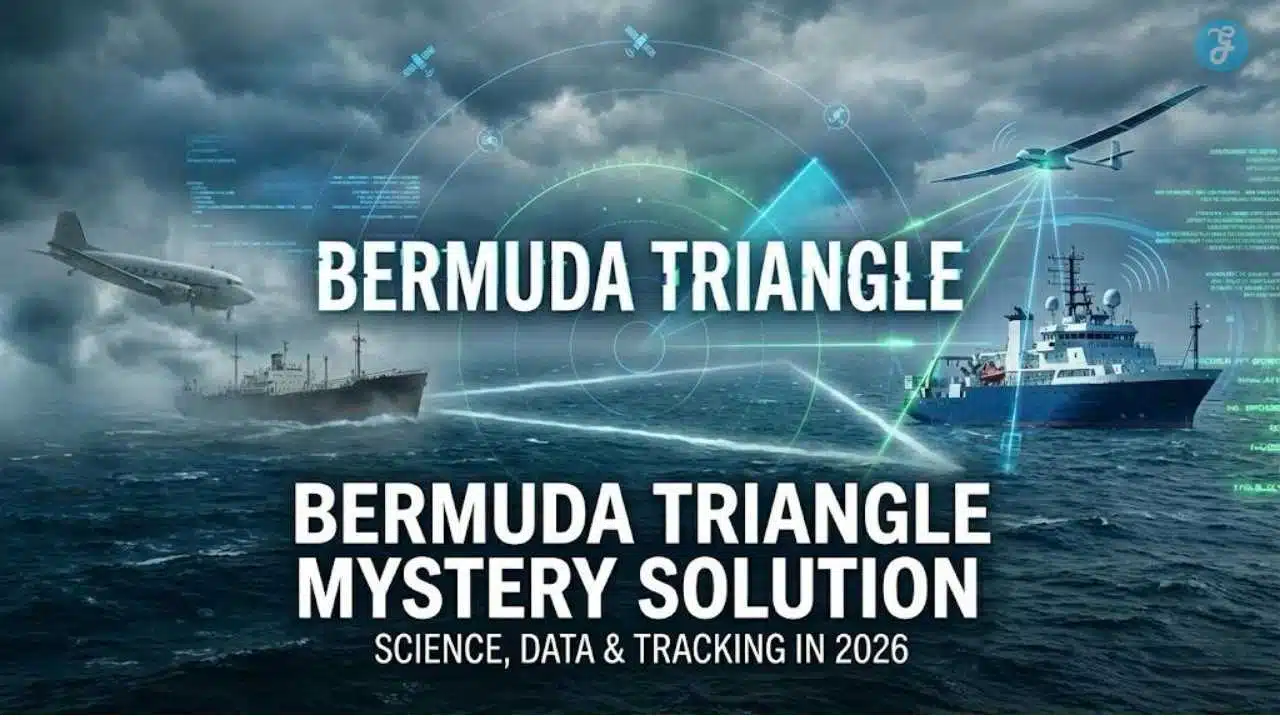
For decades, the search for a definitive Bermuda Triangle mystery solution has focused on finding a “smoking gun”—whether that be magnetic anomalies, rogue waves, or something otherworldly. However, the true answer isn’t a single “aha” moment found on the ocean floor; it is a complex, evolving story about how we measure risk, interpret data, and utilize modern tracking to make the unknown visible.
In this light, the Bermuda Triangle mystery solution is not about proving what happened in 1945, but explaining why “vanishing without a trace” is becoming nearly impossible today. It is a transition from an era of silence and speculation to an era of surveillance and certainty.
Key Takeaways: The Real Solution
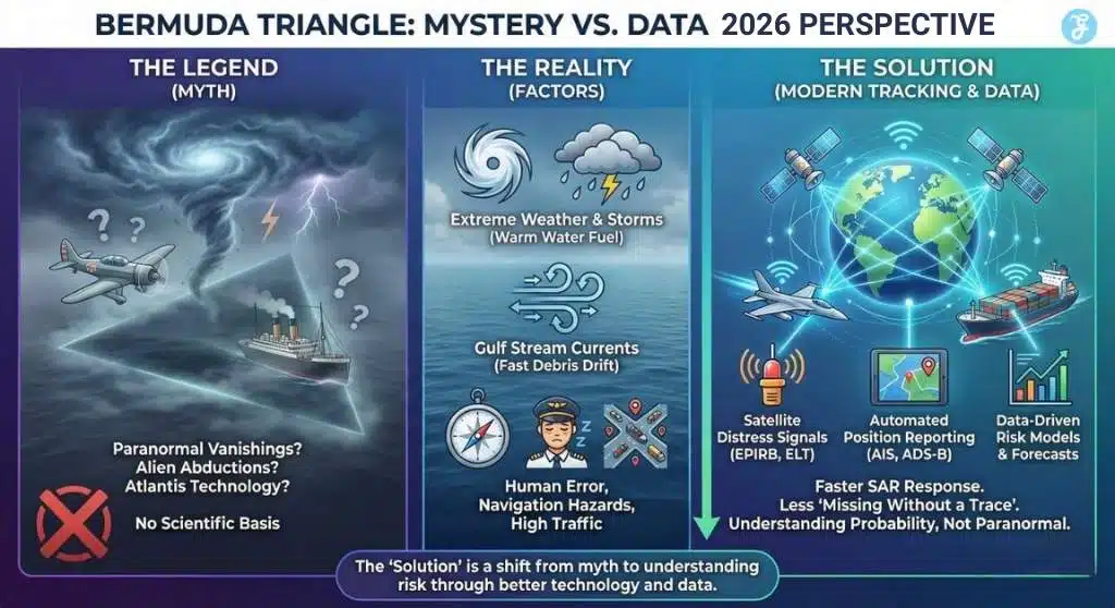
The Bermuda Triangle mystery solution isn’t paranormal; it is a mix of extreme physics and new technology that is finally closing the case.
-
Physics Clears the Scene: The Gulf Stream flows at speeds up to ~9 km/h (5.6 mph). This powerful current can sweep wreckage miles away from a crash site in hours, creating the illusion of a disappearance “without a trace.”
-
2026 Ends the Silence: New ICAO standards require aircraft in distress to broadcast their position every minute. Combined with modern satellite ship tracking (AIS), the “data gaps” that fueled the legend are now gone.
-
Risk is Ordinary, Not Magic: NOAA and the Coast Guard confirm the region has no higher accident rate than other busy areas. The real threats are standard maritime risks: human error, sudden storms, and machinery failure.
Why this matters now
The Bermuda Triangle is trending again because it sits at the intersection of three big 2026 realities:
(1) more extreme-weather awareness and ocean-heat conversations
(2) rapid advances in satellite tracking for ships and aircraft
(3) an online misinformation ecosystem that rewards mystery over probability.
The result: the public debate often asks, “Will it ever be solved?” But a better, more practical question is: Solved in what sense—scientifically, operationally, or culturally?
How we got here: The Bermuda Triangle
The Bermuda Triangle is a loosely defined region often drawn between Florida (Miami area), Bermuda, and Puerto Rico. Even its “borders” are informal—NOAA notes there are no official maps that define it, and the U.S. Board on Geographic Names does not treat it as an official place-name.
The modern legend accelerated in the mid-20th century, amplified by a few headline-grabbing incidents and then by popular books and TV. But U.S. agencies have consistently pushed back on supernatural claims. NOAA explicitly states the U.S. Navy and U.S. Coast Guard see no supernatural explanations, and NOAA adds there’s no evidence that disappearances happen more frequently there than in other heavily traveled ocean areas.
The Coast Guard’s own historical FAQ is even more direct: it does not recognize the Triangle as a special hazard zone and says reviews of losses have found no extraordinary factors beyond physical causes.
Core analysis: what actually drives risk in the “Triangle”
This section provides the evidence-based Bermuda triangle mystery solution, moving beyond folklore to identify the three tangible forces that actually drive risk in the region.
1) Nature is dramatic there, but not unique
NOAA’s summary points to very ordinary (and very dangerous) ingredients: hurricanes and tropical storms, fast-changing weather influenced by the Gulf Stream, and navigation hazards in shallow-water island chains.
Two Gulf Stream details matter for the “no trace” myth:
- Speed and debris drift: NOAA estimates the Gulf Stream averages ~6.4 km/h (4 mph), with typical maximum speeds around ~9 km/h (5.6 mph) near the surface. That’s enough to move floating wreckage away from the last known position faster than many people intuit.
- Storm intensification context: NOAA’s satellite service (NESDIS) highlights that temperature contrasts along the Gulf Stream can increase cyclone intensity, and warm pools around ~78°F (≈26°C) or warmer can help a storm intensify. In plain terms, warm water is fuel.
Climate context adds another layer: WMO’s State of the Climate 2024: Extreme Events Supplement reports 86 tropical cyclones globally in 2024, with the North Atlantic at 18 above average. Even if the Bermuda Triangle isn’t “special,” it’s inside a basin where tropical cyclone exposure remains a central navigation risk.
Bottom line: The Triangle isn’t magic; it’s a busy patch of ocean where weather can turn fast, and currents can disperse evidence.
NOAA’s framing is blunt: “nature and human fallibility” are enough. That matters because many “mystery” accounts compress complex chains of decisions into a single spooky headline: a late departure, marginal maintenance, overloaded cargo, poor visibility, fatigue, outdated charts, radio issues, and then a bad-weather trigger. That’s not paranormal—it’s how accident risk compounds.
A useful reality check is broader maritime casualty data: Lloyd’s List Intelligence has reported machinery damage/failure and collisions as leading incident drivers (e.g., machinery damage/failure and collisions as prominent categories in their casualty reporting). While this isn’t Bermuda-specific, it underscores a core point: most losses at sea are explainable through engineering, operations, and weather—not portals.
3) “Vanished without a trace” is often a tracking problem, not a physics problem
Here is where 2026 genuinely changes the story.
At sea:
- The IMO explains AIS carriage requirements under SOLAS: AIS is designed to broadcast identification/position to other ships and coastal authorities; requirements apply broadly to passenger ships and many cargo vessels.
- Satellites are increasingly central to distress communications. IMSO (which oversees satellite communications elements of GMDSS) says that in 2022, there were 900+ distress alerts transmitted and 500,000+ safety messages broadcast to ships (weather forecasts, navigational warnings).
- NOAA SARSAT describes 406 MHz beacons (EPIRBs for maritime, ELTs for aviation, PLBs for personal use) that transmit digitally coded distress signals.
In the air:
Post-MH370, aircraft tracking became a regulatory priority. FAA guidance notes MH370 disappeared on March 8, 2014, prompting ICAO work that led to aircraft-tracking standards taking effect in 2018 for certain operations. The FAA guidance also summarizes a key operational benchmark: automated position reporting at least every 15 minutes in relevant contexts.
And the forward edge is sharper in 2026: IATA’s overview of ICAO GADSS/ADT notes an ICAO standard that requires certain new large aeroplanes to autonomously transmit position information at least once every minute when in distress.
Why this matters for the Bermuda Triangle myth: the classic narrative—“no wreckage, no signals, no proof”—depends on sparse tracking. Satellite distress systems and more frequent automated position reporting don’t eliminate accidents, but they reduce the chance that a disappearance becomes an open-ended legend.
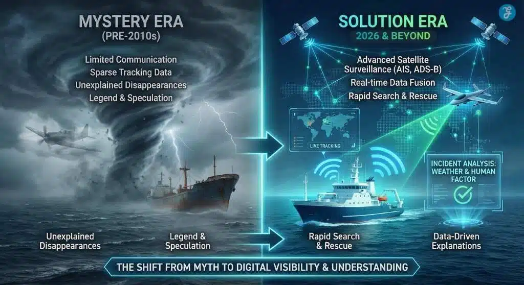
Data & visualization: what changed from “mystery era” to “traceable era”
Key statistics (high-signal, not sensational):
- Gulf Stream average speed: ~6.4 km/h (4 mph); typical maximum near-surface: ~9 km/h (5.6 mph)
- WMO 2024 tropical cyclones: 86 globally, 18 in the North Atlantic
- GMDSS satellite communications (IMSO): 900+ distress alerts and 500,000+ safety broadcasts in 2022
- Aviation aircraft tracking (FAA guidance): ICAO tracking standards effective Nov. 8, 2018; recommends automated reporting at least every 15 minutes in relevant airspace contexts
- ICAO distress tracking (via IATA summary): Certain aircraft must transmit at least once per minute when in distress
Comparison: The “mystery” shrinks as surveillance grows
| Era | What people thought was happening | What was actually missing | What changed the most |
| Pre-1970s | Disappearances “without cause.” | Limited weather forecasting, sparse comms | Better forecasts and radio procedures begin |
| 1970s–2000 | Triangle becomes pop-culture shorthand | Inconsistent vessel/aircraft tracking | GPS adoption, improved SAR coordination |
| 2000–2014 | “Still no trace” stories persist online | Gaps in global flight/ocean tracking | Wider AIS use; satellite surveillance expands |
| 2014–2026 | Post-MH370 anxiety drives reforms | Need for faster last-known-position certainty | ICAO aircraft tracking standards + 2025 distress tracking requirements |
Expert perspectives: why credible institutions still won’t call it “solved”
A neutral analysis has to recognize two truths at once:
- Agencies are confident there’s no paranormal mechanism: NOAA and the Coast Guard explicitly reject supernatural claims, and the Coast Guard says it has found no extraordinary factors in reviewing losses.
- They cannot “solve” a legend the way you solve a case file: Many historic incidents lack complete logs, wreckage, or consistent reporting. A missing vessel in 1918 or a confused radio call in 1945 will never be reconstructed with the fidelity we expect today. That gap is precisely where myths live.
This is also where psychology and media dynamics matter. The American Psychological Association summarizes research showing people can be drawn toward conspiracy-style explanations under threat, uncertainty, and a reliance on intuition. That doesn’t mean Bermuda Triangle believers are irrational; it means humans are pattern-seeking under ambiguity—and ambiguity is common in ocean and aviation incidents.
So “solving” the Triangle isn’t only an engineering task. It’s also a trust-and-communication task.
The look ahead: what to watch next
This section outlines the future trajectory of the Bermuda Triangle narrative, predicting a shift from “mystery” to “management.” It highlights three key trends:
1) A practical “solution” is emerging: fewer legends, faster answers
If you define the Bermuda triangle mystery solution as reducing the number of cases that become mysteries, the trajectory is clear: more AIS coverage, more satellite distress messaging, more frequent aircraft tracking in emergencies, and better modeling of drift and weather.
The next frontier is integrating these streams so the “search” part of search-and-rescue shrinks further—less time spent guessing where something went down, more time spent responding.
2) Climate and ocean heat keep the risk conversation alive
Even as tracking improves, hazard exposure remains. WMO’s reporting shows tropical cyclone activity remains a major global feature, and NOAA’s own satellite service underscores how warm-water patterns can influence storm behavior. This doesn’t make the Triangle “cursed,” but it does keep the region—and the wider Atlantic—operationally important for safety planning.
3) The cultural myth may be the hardest thing to “solve”
The Coast Guard can dismiss paranormal claims. NOAA can explain weather, currents, and navigation. Regulators can require better tracking. But myths persist because they’re useful stories—simple explanations for complex, frightening randomness.
In that sense, the Bermuda Triangle’s “final solution” may not be a discovery in the sea. It may be a slow shift in how audiences value evidence over intrigue—and how platforms reward accuracy over virality.
Frequently Asked Questions: The Bermuda Triangle Mystery
Has the Bermuda Triangle mystery finally been solved?
Yes, but not in the way you might expect. The Bermuda Triangle mystery solution isn’t a single discovery like a pyramid or a portal. Instead, it is the result of modern data proving that “mysterious” disappearances are actually caused by a mix of human error, rapid environmental changes (like the Gulf Stream moving debris), and previously poor tracking technology.
Why do so many ships and planes seem to vanish there?
They don’t vanish as often as the legend suggests. NOAA and the Coast Guard note that the frequency of accidents in the Triangle is no higher than in any other heavily traveled ocean area. When vessels do disappear, the Gulf Stream—which can flow at nearly 9 km/h (5.6 mph)—can sweep wreckage miles away from the crash site before rescuers arrive, making it look like they “vanished without a trace.“
Are there rogue waves or methane gas bubbles causing the accidents?
While natural phenomena exist, the article points to more ordinary risks as the primary drivers. The real danger comes from sudden tropical storms, warm water ($\approx$26°C+) that fuels cyclone intensity, and the difficult navigation around shallow island chains. Most losses are attributed to physical causes like machinery failure or weather, not exotic theories.
How will new technology stop planes from disappearing?
The “traceable era” has begun. New ICAO standards require commercial aircraft to autonomously transmit their position at least once every minute when in distress. This, combined with universal AIS ship tracking and satellite distress beacons, means that even if an accident happens, authorities will know exactly where and when it occurred, preventing the formation of a new “mystery.“
No. The U.S. Board on Geographic Names does not recognize the Bermuda Triangle as an official name, and the Coast Guard states there are no “extraordinary factors” involved in casualties there. They view it simply as a busy patch of ocean where weather and human error sometimes lead to accidents.
Is the Bermuda Triangle still dangerous today?
It is dangerous, but due to the climate rather than curses. The region is a hotspot for tropical cyclones and extreme weather. With ocean heat increasing storm intensity, it remains a challenging environment for navigation, but these are manageable operational risks, not supernatural ones.
The Bottom Line: A Solution Hidden in Plain Sight
Ultimately, the search for a definitive Bermuda Triangle mystery solution forces us to accept a reality that is far less sensational than the legend, but far more important for modern safety. The “solution” is not a physical discovery of Atlantean ruins or a time portal; it is the accumulation of cold, hard data.
We now know that the region’s risks are driven by a volatile mix of rapid currents (the Gulf Stream moving wreckage at nearly 9 km/h), intensifying weather fueled by ocean heat, and the ever-present factor of human fallibility. Agencies like NOAA and the Coast Guard have long considered the case closed based on these physical facts, noting that no supernatural explanation is required for accidents in a heavily traveled ocean corridor.
Therefore, the Bermuda Triangle mystery solution is not about unearthing a secret; it is about a shift in perspective. The mystery survives not because the ocean is inexplicable, but because the human mind often prefers a frightening legend over a complex, technical truth. The final piece of the puzzle isn’t found in the water—it is found in our willingness to prioritize accuracy over intrigue.