
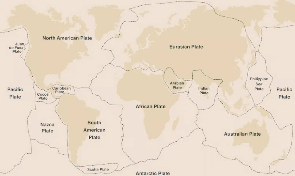
Earthquakes are terrifying natural disasters that can cause damage to buildings, infrastructure, and even entire cities. Bangladesh is one of the most seismically active areas in the world due to its position where three tectonic plates converge – The Indian Plate, the Eurasian Tectonic Plate, and the Burmese Plate.
This blog post will discuss what causes earthquakes in Bangladesh; India’s risk factors for a massive earthquake; the impact of past quakes; how to prepare for these events and how to mitigate the risks associated with them.
Get ready as we explore why plate boundaries play an important role in understanding seismic activity – let’s begin!
Content Highlights
- Tectonic plates are large sections of the Earth’s crust and upper mantle that move, leading to seismic activity and natural disasters. These are the driving forces behind earthquakes, volcanoes, mountains, and various landforms.
- Tectonic activity is classified into three main types: Divergent, Convergent, and Transform Plate Boundaries. Different types of plate boundaries pose varying levels of seismic risk.
- The convergence of the Eurasian and Indian plates increases the risk of earthquakes in Bangladesh and India. Subduction zones, fault lines, and building construction contribute to earthquake vulnerability in these regions. High population densities and urbanization in these areas make earthquake preparedness crucial.
- Monitoring and measuring seismic activity through seismometers is vital for earthquake prediction and preparedness. Early warning systems can provide valuable time for protective measures before a major earthquake. Data from seismometers also informs building codes and design standards to enhance earthquake resilience.
- Plate tectonics cause earthquakes, volcanic eruptions, tsunamis, and landslides.
Latest Update: 2,400 dead in Afghanistan earthquake
What Is a Tectonic Plate and How Does It Work?
Tectonic plates are large, solid pieces of the Earth’s crust that move slowly relative to each other, causing forces that create seismic activity and other natural disasters.
Movement of Tectonic Plates
The Earth’s lithospheric plates, which comprise the crust and part of the upper mantle, are in constant motion. The movement of these plates is called plate tectonics, and this is what creates earthquakes, volcanoes, mountains, and other landforms.
Tectonic activity can be classified into three main types as follows:
Different Types of Tectonic Plate Boundaries
[Video Credits @MooMooMath and Scince]
There are mainly 3 types of Tectonic plate boundaries, and those are: 1) Divergent Plate Boundaries, 2) Convergent Plate Boundaries, and 3) Transform Plate Boundaries. To understand why earthquakes occur, being familiar with the different types of plate boundaries is important.
- Divergent Plate Boundaries (also known as Constructive Plate Boundaries): Occur when two plates move away, causing the crust to be split and stretched, often resulting in seismic activity and volcanism.
- Convergent Plate Boundaries (also known as Destructive Plate Boundaries): Occur when two plates collide, resulting in one plate being subducted below the other—this creates high levels of volcanic activity and increases the risk of large earthquakes due to pressure buildup along fault lines.
- Transform Plate Boundaries (Also known as Conservative Plate Boundaries): Where two plates slide past each other horizontally without creating or destroying new crust; this type of boundary still poses an earthquake risk depending on how quickly the movement is occurring between the plates on either side of it.
Plate Tectonics and Earthquakes
Plate tectonics is the structural dynamics of Earth’s lithosphere, which includes the crust and upper mantle. This dynamic system involves a continuous process of plate movement, collision, formation, and sometimes rupture along plate boundaries.
Earthquakes occur along these plate boundaries when there is an abrupt shift in plates that are moving in opposite directions. Each type of boundary offers different risks for seismic activity:
Divergent plates move away from each other causing small earthquakes and creating new oceanic lithosphere, while convergent plates collide pushing up mountain ranges as continents interact with one another or subducting deep beneath them — increasing the risk for major seismic events such as large-scale earthquakes.
Transform plate motions create lateral pressures on the edges of adjacent plates resulting in strike-slip fault motion which can cause devastating destruction from ground shaking and interplate seismicity occurring thousands or even millions of years later due to changes to accumulated stress patterns caused by slowly shifting tectonic forces over time.
Here’s a simplified version of different types of plate boundaries and their effects in general:
|
Plate Boundary |
Plate Movement |
Seismic Activity |
|
Divergent |
Plates move away from each other |
Small earthquakes, creation of new oceanic lithosphere |
|
Convergent |
Plates collide |
Major earthquakes, mountain building, subduction |
|
Transform |
Plates slide past each other horizontally |
Strike-slip fault motion, earthquakes, interplate seismicity |
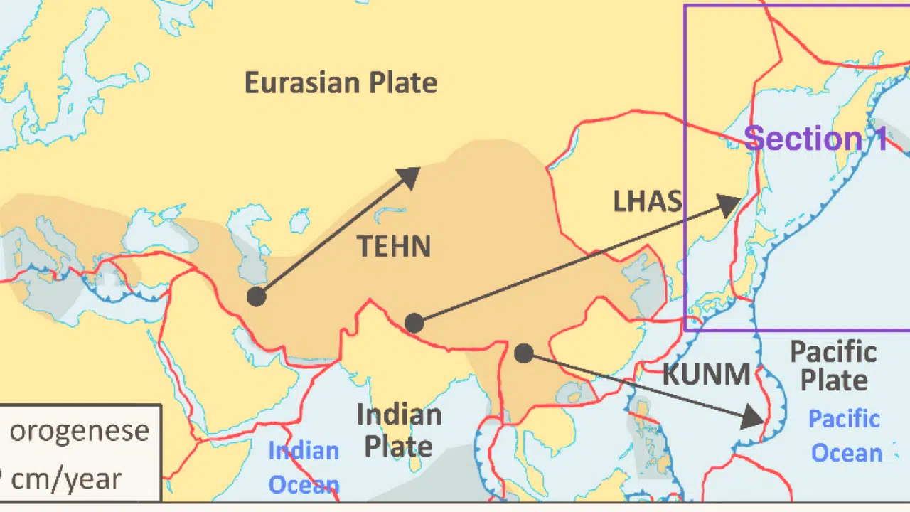
A Closer Look at the Eurasian Tectonic Plate
Spanning nearly 67.8 million square kilometres (26.18 million square miles) and encompassing roughly 13 percent of the Earth’s surface, the Eurasian Tectonic Plate is one of the Earth’s largest plates.
Location and Size
The Eurasian Plate is one of the largest (third largest) tectonic plates in the world, with an area extending from Europe to China and Russia. It stretches from the Azores and Canary Islands near the Atlantic Ocean across mainland Europe into portions of Siberia, parts of Central Asian countries, Southwest Asia into India, including Bangladesh.
The plate is 26.18 million square miles (67.8 million square kilometers) and covers almost 13% of Earth’s surface.
Its interactions with both the Indian Plate directly and to East-northeast across 200km allying along a megathrust fault line give rise to most great earthquakes affecting such regions as New Delhi and Dhaka.
Motion and Interactions With Other Plates
The Eurasian Plate tends to move at a variable rate, ranging between 0.7 centimeters per year and 1.4 centimeters per year, due to the convergence of convergent, divergent, and transform fault boundaries.
The Eurasian Plate is involved in motion and interacts with other major plates. The Indian Plate is converging northward, pushing against the Eurasian Plate resulting in the uplift of the Tibetan Plateau and Himalayas.
This convergence has caused strong seismic activity along their boundaries leading to infrequent yet large earthquakes such as the 1991 Uttarkashi earthquake and 2004 Indian Ocean earthquake and tsunami.
Other interaction between plates such as Burmese or Sunda plays a role in this tectonic system, making it quite complex, so predicting exact locations for these earthquakes remains difficult.
The Role of Plate Boundaries in Earthquake Occurrence
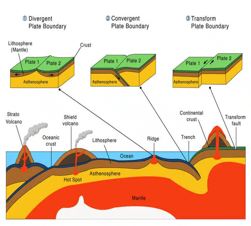
Plate tectonics plays a major role in the occurrence of earthquakes, with some plate boundaries being more prone to seismic activity than others.
Divergent Boundaries
Divergent boundaries occur along the Eurasian tectonic plate, where two continental or oceanic plates move away from one another. Some of the most well-known divergent boundary regions are found at mid-Atlantic ridges and East African rifts.
These boundaries result from the separation of lithospheric plates due to molten magma rising up from the asthenosphere below them. They also involve processes such as seafloor spreading and subduction which can lead to volcanic activity occurring in these areas.
Not only can this activity trigger powerful earthquakes but it can also form large central volcanoes—for example, Mount Ruapehu formed off New Zealand’s North Island by a divergent plate boundary.
Convergent Boundaries
Convergent boundaries occur when two plates collide. They create a highly active tectonic zone with intense folding and faulting, leading to the formation of mountain ranges like the Himalayas.
Earthquakes can occur when great stress builds up due to convergent plates pushing into each other, resulting in the release of energy. About 80% of all earthquakes happen at convergent plate boundaries which makes it one of the most hazardous types of boundary on Earth.
The collision between the Indian Plate and the Eurasian Plate created a subduction zone responsible for powerful shallow-focus earthquakes that hit Bangladesh and India from time to time.
The immense pressure created by these collisions also results in significant folding and deformation along the continental margins, forming majestic mountain ranges such as the Himalayas with growing intensity over geologic timescales caused by continuous convergence movement taking place between these two tectonic plates for millions of years now.
Transform Boundaries
Transform boundaries are a type of plate boundary that occurs when two plates move in opposite directions. If the two plates are roughly along the same line, such as with the Eurasian and Indian Plates, they form what is known as a transform fault.
Transform faults have steep rupture surfaces which can cause seismic activity to be limited to a narrow zone along these boundaries. The transform faults on either side of the India Plate are responsible for many earthquakes in Bangladesh and India, due to their active tectonic setting and frequent collisions between different tectonic plates from around Eurasia.
Earthquakes at transform boundaries tend to be smaller but more frequent than those occurring from divergent or convergent plate boundaries, making them difficult to predict, yet luckily also less destructive over large areas like divergent or convergent plate movement would create.
Are Bangladesh and India Vulnerable to Earthquakes?
[Video Credits @Bangladesh Circle]
The convergence of the Eurasian and Indian plates, subduction zones, fault lines, and building construction and infrastructure are all potential risk factors for a massive earthquake in Bangladesh and India.
How the Convergence of The Eurasian and Indian Plates Threatens Bangladesh and India
The convergence of the Eurasian and Indian plates creates a major continental collision that puts Bangladesh and India at greater risk of experiencing earthquakes. The Indian Plate slides beneath the Eurasian Plate, forming a convergent boundary between their edges.
This process causes friction which results in deformation and seismic activity along the plates’ contact points, producing shallow and deep-focus earthquakes as well as tsunamis.
Earthquakes caused by this tectonic interaction generally have higher magnitudes compared to those caused by oceanic plates converging or spreading apart elsewhere on Earth.
Seismologists suggest that between 50-60% of all seismicity along the Bengal region appears associated with strike-slip fault motions created by regional tensions caused by the movement of these two plates colliding together – a deadly combination for both Bangladesh and India!
Subduction Zones and Fault Lines: The Ticking Time Bombs of Bangladesh and India
Subduction zones and fault lines are two important geological features that can cause massive earthquakes in Bangladesh and India, caused by the ongoing convergence of the Eurasian Plate and Indian Plate.
Subduction zones occur when one plate slides or is forced under another creating a steep angle along the Earth’s surface accumulating energy released during an earthquake.
In this region, subduction extends across about 250 km from the border of Eastern Nepal to the Andaman islands posing a high risk for an 8.2-9.0 magnitude earthquake if it were suddenly unleashed.
The Dauki, Jamuna, and Chittagong-Myanmar faults in Bangladesh are still active making them more vulnerable to devastating seismic activity while several other smaller faults have also been detected adding further to the already existing risk levels.
Building Construction and Infrastructure: A Double-Edged Sword in Bangladesh and India
Bangladesh and India have some of the highest population densities in the world, coupled with strong urbanization occurring across these regions. This increases the potential impact of earthquakes on buildings and infrastructure such as bridges, roads, and tunnels that are essential connections between people’s homes.
Unfortunately, many building construction practices in Bangladesh and India may not be designed to withstand seismic activity effectively which can exacerbate existing vulnerabilities of structures during an earthquake.
Furthermore, emergency response plans also need significant improvements for greater preparedness against disasters such as earthquakes caused by plate tectonics, especially in highly-populated urban areas like Dhaka city.
Measures must also taken to reduce the vulnerability of buildings and infrastructure to earthquake damage seen in past events by retrofitting existing structure designs or replacing outdated structures entirely.
The Impact of Past Earthquakes in The Region
The past earthquakes in Bangladesh and India have had devastating impacts, including loss of life and severe damage to infrastructure. Educating ourselves on these incidents allows us to better prepare for future disasters.
1991 Uttarkashi Earthquake
The 1991 Uttarkashi earthquake was one of the most devastating earthquakes to have occurred in India.
The earthquake occurred on 20 October at 02:53:16 IST with a magnitude of 6.8 (Exactly the same magnitude as the earthquake in Morocco in early September this year) and had a maximum Mercalli intensity of IX (Violent), causing widespread damage across the Uttarkashi district in Uttarakhand, India.
It was associated with the plate boundary between Eurasia and India which is known for its tectonic activity; this seismic event highlighted that region’s susceptibility to future earthquakes due to ongoing convergence between these two plates.
Besides causing destruction, it also gives us insight into understanding how our environment works, showing us where geologic risk lies along tectonic boundaries and other fault lines to prepare for future disasters.
2004 Indian Ocean Earthquake and Tsunami
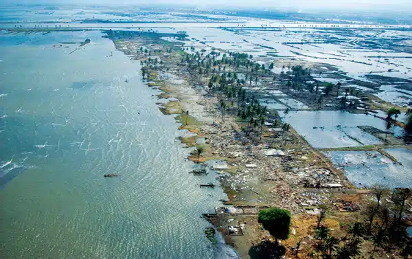
The 2004 Indian Ocean Earthquake & Tsunami occurred off the western coast of Sumatra, Indonesia on December 26, with a magnitude of 9.1-9.3 making it one of the most powerful earthquakes ever recorded.
It was also the cause of one the most devastating tsunamis in modern times, affecting 18 countries in South and Southeast Asia. The tsunami caused immense destruction along many coasts and led to massive loss of life – an estimated 283,000 casualties were reported with another 1 million displaced by flooding or destroyed housing in this region.
The movement along a tectonic subduction zone between the Indian Plate and the Eurasian Tectonic Plate created a major seismic activity that triggered an underwater landslide resulting in huge waves that caused widespread destruction across several countries at great distances from its epicentre, as far as Somalia in Africa’s eastern shoreline being affected due to these lethal waves produced more than 5 km away from their origins underwater.
Lessons Learned and Improvements Made in Building Construction and Infrastructure in Bangladesh and India
Over the years, governments and communities in Bangladesh and India have made numerous efforts to learn from past earthquakes and make improvements to reduce potential damages during future disasters.
Past earthquake disasters such as the 1991 Uttarkashi earthquake, the 2004 Indian Ocean tsunami, and the 5.2 magnitude earthquake in Bangladesh have triggered international aid agencies to intensify their programs for preventing loss of life during natural calamities. Today’s building standards across both countries are far better than what they were in the past.
Earthquakes: How to Predict and Prepare for Them?
Utilizing monitoring systems to detect seismic activity and measure the intensity of potential earthquakes is an important step in preparing the region for future natural disasters.
Monitoring and Measuring Seismic Activity: A Critical Step in Earthquake Preparedness
It is important to monitor and measure seismic activity to predict and prepare for earthquakes. This involves installing and maintaining a network of seismometers, which are instruments that detect and measure ground motion caused by earthquakes. Seismometers can be used to track the movement of fault lines and identify areas that are at high risk of earthquakes.
In Bangladesh and India, there are a number of organizations that are responsible for monitoring and measuring seismic activity. These include the Bangladesh Meteorological Department, the Indian Meteorological Department, and the National Geophysical Research Institute. These organizations operate a network of seismometers throughout the region, and they collect and analyze data on seismic activity.
The data collected from seismometers can be used to develop a variety of earthquake early warning systems. These systems can detect moderate-intensity tremors before a major quake occurs, and they can provide people with enough time to take protective measures.
In addition to developing early warning systems, the data collected from seismometers can also be used to improve building codes and design standards. This can help to ensure that buildings are constructed to withstand earthquakes and that they can be safely evacuated in the event of a quake.
Monitoring and measuring seismic activity is a critical step in earthquake preparedness. By understanding the seismic risks in a region, governments and communities can take steps to mitigate the impact of earthquakes and protect people’s lives and livelihoods.
A Race Against Time: Emergency Response Plans and Infrastructure in The Face of Earthquakes in Bangladesh and India
Measures taken by the government and the community to prepare for earthquakes involve monitoring and measuring seismic activity, developing emergency response plans, and establishing infrastructure to support disaster response.
Governments have started installing earthquake early warning systems that can detect moderate-intensity tremors before a major quake occurs.
For example, in India, Disaster Management teams carry out drills annually to help communities prepare for any natural disasters like earthquakes. These exercises include mock rescue operations for trapped victims from simulated disaster sites.
The infrastructure surrounding quake-prone areas has also been improved with stronger engineered materials specifically designed to withstand seismic events while minimizing damage or destruction of property in case it does occur.
Increased public knowledge about what steps need to be taken before and during an earthquake is being disseminated on mass media platforms such as television broadcasts or online sources.
How to Raise Public Awareness of Earthquake Risks in Bangladesh and India?
Both India and Bangladesh are located in a highly seismic region and are both at risk of experiencing devastating earthquakes in the future.
There are a number of things that can be done to raise public awareness of earthquake risks in Bangladesh and India. Here are a few suggestions:
- Educate children about earthquake safety: Earthquakes are natural hazards that can strike at any time, so it is important to teach children about earthquake safety from a young age. This can be done through school programs, public awareness campaigns, and community events.
- Develop and implement earthquake preparedness plans: Earthquake preparedness plans should be developed at the community, district, and national levels. These plans should identify earthquake risks, outline evacuation procedures, and provide information on how to stay safe during an earthquake.
- Promote earthquake safety through the media: The media can play a vital role in raising public awareness of earthquake risks. Governments and disaster management agencies should work with the media to develop and implement public awareness campaigns.
- Use social media to reach a wider audience: Social media platforms such as Facebook, Twitter, and Instagram can be used to reach a large number of people with information about earthquake safety. Governments, disaster management agencies, and other organizations should develop social media campaigns to raise public awareness of earthquake risks.
It’s crucial to tailor earthquake awareness campaigns to the specific needs of different communities. For example, campaigns should be available in multiple languages and consider different communities’ cultural and religious beliefs.
By taking these steps, we can raise public awareness of earthquake risks in Bangladesh and India and help to save lives in the event of a major earthquake.
Mitigating The Risk of Earthquakes
Governments, communities, and individuals must work together to develop strategies for reducing the risks of earthquakes, from disaster preparedness plans to retrofitting existing buildings and infrastructure.
Government Initiatives and Policies
Bangladesh and India are working to mitigate the risk of earthquakes related to the Eurasian Tectonic Plate.
Measures taken by both countries to address potential seismic activity include assessing and enhancing preparedness in urban areas, raising awareness about earthquake risks, and educating the public about available mitigation measures.
For example, Dhaka is an area that faces a high risk for moderate to strong earthquakes due to its convergence of three tectonic plates: The Indian-Eurasia-Burma plate converging together.
To reduce the impact should such an event occur, Bangladeshi authorities have established retrofitting regulations regarding building structure, stricter zoning requirements in order to prevent overcrowding and more robust emergency plans should any aid be needed during/after an earthquake or other emergency scenario.
In India, several government initiatives, including the “Disaster Management Program,” focus on developing a mixed approach between proactive prevention and proactive preparedness models, as set forth by UNISDR (United Nations International Strategy for Disaster Reduction).
Key aspects include initiating thesis projects around relative topics, such as crowd dynamics analysis, along with the delivery of clear warning messages throughout vulnerable locales using media outlets such as television and radio broadcasting devices at an instant’s notice on the occasion of initial tremors or signs of physical disturbance from Earth’s crust layer leading up to large-scale seismic events like earthquakes.
India’s seismic activity indents its deep roots over the Indian subcontinent’s soil bed periodically, keeping seismographic radars under surveillance 24×7 across cities and the nation. This entails changing attention towards shifting factors dictating outbreak magnitude assessment beforehand, which has been kept under wraps and too abstractly mentioned, rendering the task of peripheral detection tougher without implementation.
Constructive data collection projects pertaining to disaster management have driven forward innovative social engineering strategies, contributing to earthquake regulation checks.
These initiatives have been implemented recently, with significant upgrades from previous approaches, even in older, considered hazardous regions. This marks a starting point guided by extrapolation computation, giving solution deployment priority whenever either zone touches a new threshold limit.
Community Involvement And Education
This is an important element in risk mitigation against earthquakes in Bangladesh and India.
Raising community awareness about the risks associated with seismic activity, as well as promoting preparedness for any potential earthquake, can help mitigate the severity of the impact on communities.
Furthermore, public engagement allows communities to actively identify underlying problems causing vulnerability and develop effective risk prevention measures.
People’s perceptions and interpretations of seismic hazards significantly influence their risk-taking decisions; therefore, it is essential to understand these perceptions and address them to increase resilience among individuals who have experienced or witnessed a destructive earthquake before.
Such measures could involve retrofitting unsafe buildings according to regulations set by government bodies and international standards such as those provided by the International Building Code (IBC), American Society for Testing & Materials (ASTM), etc. so that more people can be better protected from major quakes.
Retrofitting Buildings And Infrastructure
Retrofitting building structures is a process of strengthening existing buildings and infrastructure that are vulnerable to earthquake damage. It involves the modification of an existing structure’s design and construction features to increase its seismic strength, resistance, or durability.
Different techniques and strategies for retrofitting can include improving foundations, adding diagonal braces in walls, installing dampers or shock absorbers on rooftops, increasing steel connections throughout the structure, and replacing un-reinforced masonry sections with reinforced ones.
Implementing these types of strategies will help improve structural integrity over time by reducing strain during earthquakes thus helping reduce potential damage as well as people’s exposure to risk when such disasters occur.
Government initiatives such as those implemented in India after the tsunami in 2004 have also played an important role in raising awareness about earthquake preparedness amongst communities living close to tectonic plate boundaries, where large earthquakes tend to take place more frequently than elsewhere.
Accordingly, proper infrastructure has been developed and distributed properly so that affected individuals can use them appropriately at times like these.
Plate Tectonics: The Natural Force Behind Many Common Disasters
Plate tectonics can also cause other natural disasters such as volcanic eruptions, tsunamis, and landslides. Discover how these risks can be mitigated today!
Volcanic Eruptions
Volcanic eruptions are violent and spectacular events that occur when molten rock, or lava, is forced out of an underlying magma chamber at the Earth’s surface. They can be a result of the movement of Earth’s crust, which is divided into separate sections known as tectonic plates.
Volcanoes often form at convergent boundaries, where two tectonic plates collide together, and one slide under another.
All around the world, earthquakes are concentrated around these collision zones and they tend to disrupt stationary pressure in underground pipes of magma causing them to oscillate wildly and burst open resulting in intense volcanic activity that can spew molten rocks hundreds of meters high into the sky.
Subduction caused by diverging tectonic plates can also drive up hot mantle material that crystallizes on erupting from below creating even more violence in terms of tractor plumes and vast clouds splitting earth materials up.
Tsunamis
Tsunamis are an extreme natural disaster that can be devastating for coastal communities. They are caused by underwater earthquakes, which occur when a tectonic plate slips abruptly under or over another.
Depending on how long the displacement of plates continues and how different their depths are, the resulting seismic waves may travel at speeds up to 800 kilometers per hour across thousands of kilometres in open bodies of water before reaching shorelines.
Tsunamis primarily occur in subduction zones, which is where one plate slides beneath another such as the Indian and Eurasian Plates – both situated offshore Bangladesh and India – creating a convergence with potential for massive destruction inland due to their intense energy release during seismic activity.
One high-impact example of this occurred in 2004 when a magnitude 9.1-9.3 earthquake off Sumatra triggered a tsunami killing 250,000 people throughout southeast Asia as well as leaving half a million homeless right away.
Landslides
Landslides are a common and often catastrophic consequence of the interaction between tectonic plates. In 2015, Nepal experienced one of the deadliest landslides in recent history resulting from an earthquake that shook the region to its core.
These devastating disasters can affect both rural villages as well densely packed urban areas where infrastructure is more susceptible due to seismic activity. When triggered by seismicity or other natural factors, they can result in catastrophic losses of lives and property across widespread regions.
As such, mitigation strategies for landslides must be taken into consideration when countries in high-risk tectonic plate caution zones decide how best to establish emergency plans.
Frequently Asked Questions (FAQs)
You may also read the following frequently asked questions related to the Eurasian Tectonic Plate.
1. What Is The Eurasian Tectonic Plate?
The Eurasian tectonic plate consists of multiple large pieces of the Earth’s crust located in and around Bangladesh and India that are joined to form a single geological entity.
2. What Risk Factors Cause Massive Earthquakes in Bangladesh and India?
Active faults, seismic irregularities, tectonically active zones, sediment deposits, poor building construction standards, and vulnerable populations living close to fault lines may contribute to or cause massive earthquakes in Bangladesh and India.
3. How Does Movement Between The Indian Plate and The Eurasian Plate Impact The Risk of Earthquakes?
Movement between the Indian plate and Eurasian plate can produce friction at their boundaries, leading to increased strain building up within them until it is released as an earthquake resulting in potential risks for densely populated areas like Bangladesh & India. In some cases, differential rates of motion between these two plates create major Earthquakes like The Great Bihar – Nepal Earthquake of 1934 (Today, we call this region the ‘Himalayan Seismic Gap’ ).
4. Is There a Way to Detect Impending Seismic Activity Caused By Collisions?
Yes – monitoring systems such as seismometers are used to measure ground movements on land or sea-surface disturbances by ocean floor sensors that can be used as proxies for changes occurring before an earthquake during its development )to help detect pending seismic activity due to collision from Tectonic Plates.
Wrapping Up
Due to its unique location where the Indian Plate, Eurasian Plate, and Burmese Plate converge in Bangladesh, it is one of the most tectonically active regions in the world. This convergence creates a high risk of earthquakes occurring in Myanmar, Bangladesh, and India as well as having the potential for an extreme magnitude 9.0 earthquake or higher.
Millions of people are at risk due to this seismic activity which emphasizes the significance of government initiatives such as emergency response plans, public awareness regarding disaster preparedness, and retrofitting buildings along with community involvement and education to mitigate these risks.
Every effort must be made to reduce casualties from any future major disasters such as earthquakes that might occur in this region.