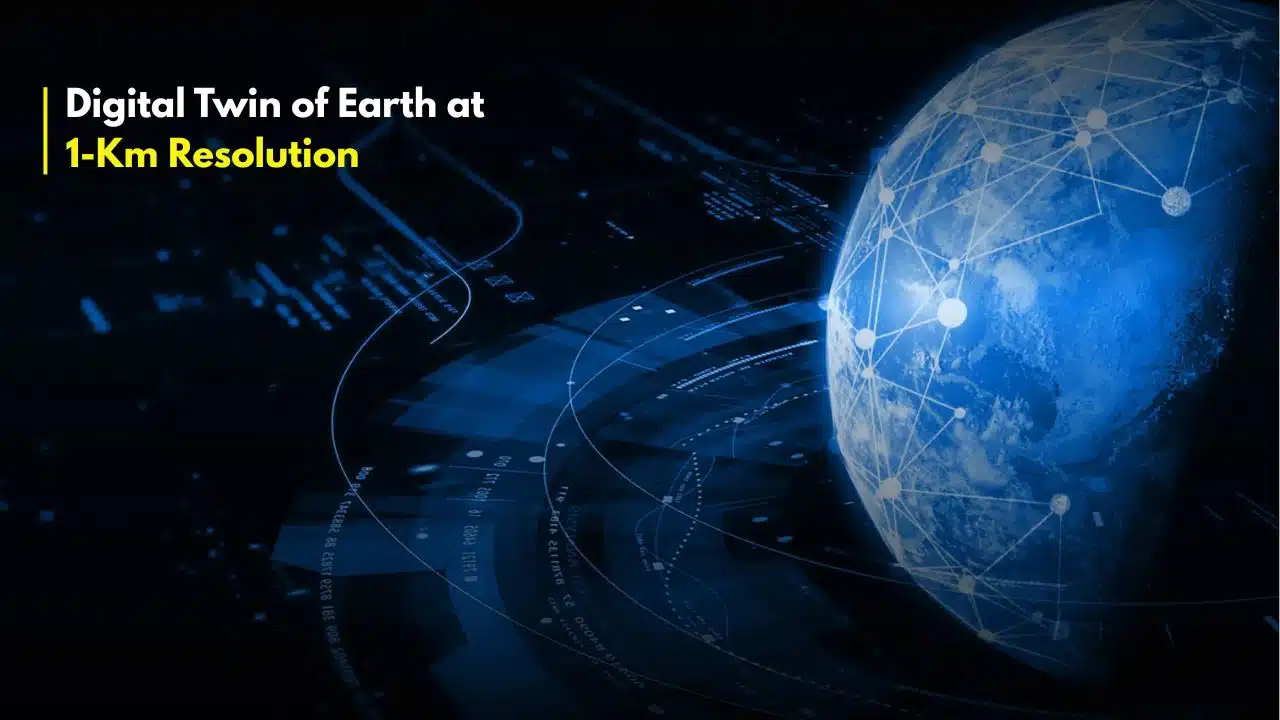
European scientists have activated the first phase of ‘Destination Earth’ (DestE), a landmark project to build a Digital Twin of Earth at 1-Km Resolution. This ambitious initiative, which went live on June 10, 2024, marks a paradigm shift from passively observing climate change to actively simulating its future impacts and our potential responses with unprecedented detail.
The project, a flagship of the European Commission’s Green Deal and Digital Strategy, harnesses some of the world’s most powerful supercomputers to create a dynamic, interactive replica of our planet. This “digital twin” will ingest real-time observational data from satellites, sensors, and ground stations to mirror the Earth’s physical systems.
Its purpose is to provide a revolutionary “what-if” engine for policymakers, scientists, and emergency services, allowing them to test the impact of environmental policies and predict the precise path of extreme weather events before they happen.
What Just Launched: The First Two Digital Twins
The June 2024 launch does not represent the final, continuous global twin. Instead, it delivers the first two operational “on-demand” twins, managed by ECMWF, which serve as the system’s foundational pillars.
- The Climate Change Adaptation Twin: This model is designed for long-term strategic planning. It allows users to run simulations at multi-decade timescales to assess the impacts of different climate adaptation and mitigation strategies. For example, a government could model the effect of reforesting a specific region or changing agricultural water-use policies, observing the projected outcomes on temperature, water resources, and biodiversity decades into the future.
- The Weather-Induced Extremes Twin: This is the high-precision, short-term forecasting tool. Operating at a resolution of 4.4 km for Europe, it provides early warnings and detailed predictions for floods, droughts, wildfires, and severe storms. Its high resolution allows it to capture the dynamics of localized events that coarser global models miss, offering actionable intelligence to emergency responders.
“The launch of the initial Destination Earth is a true game changer in our fight against climate change,” said Margrethe Vestager, the European Commission’s Executive Vice-President for a Europe Fit for the Digital Age, in a press release. “It gives us a highly accurate tool to prepare for the impacts of climate change.
The 1-Km Breakthrough: Why Resolution is Everything
The ultimate goal of a 1-km resolution is the project’s most revolutionary aspect. For decades, global climate models have operated at resolutions of 50 km to 100 km. At this blurry scale, entire mountain ranges are smoothed into gentle hills, and critical, small-scale weather events like thunderstorms (convection) cannot be simulated directly. Instead, they must be estimated using statistical “parameterisations.”
A 1-km model, by contrast, can “see” the planet’s features in high definition.
The ‘Petabyte Simulation’ Paving the Way
While DestE’s operational systems are scaling up, the 1-km global goal was recently proven feasible. In a study published in May 2024, a team of researchers from ETH Zurich and the Max Planck Institute for Meteorology, among others, successfully ran a global weather simulation at 1.4-km resolution.
Running on the LUMI supercomputer in Finland, the simulation generated staggering results:
- Data Output: The 40-day simulated run produced 1.1 Petabytes of data (1,100 terabytes).
- Computational Cost: It required the full power of one of the world’s top-five supercomputers.
“For the first time, we have been able to use a global weather model at 1 km resolution that physically represents convection,” explained Prof. Christoph Schär of ETH Zurich, a lead author of the study. This means the model can simulate the formation of a thunderstorm from basic physics, rather than guessing it. This breakthrough is critical for accurately predicting the localized, intense rainfall that causes flash floods—one of the deadliest climate impacts.
The Engine Room: The Supercomputing Challenge
A persistent 1-km digital twin of Earth is one of the most demanding computational problems ever undertaken. The DestE initiative is made possible only by the coordinated power of the EuroHPC Joint Undertaking, a network of Europe’s most powerful machines.
- Phase 1 (Current): The system relies heavily on LUMI in Finland (over 550 petaflops, or 550 quadrillion calculations per second) and MARENOSTRUM 5 in Spain.
- Phase 2 (Upcoming): The full, continuous global twin will require “exascale” computing. This power will be provided by the JUPITER supercomputer, set to be installed in Germany. JUPITER will be Europe’s first exascale machine, capable of performing over one quintillion ($10^{18}$) calculations per second.
The data management is equally daunting. The DestE “Data Lake,” managed by EUMETSAT, must handle a continuous stream of petabytes of satellite and sensor data, merge it with the simulation output, and make it accessible to users across Europe via a cloud-based platform.
Impact: A ‘What-If’ Machine for Planet Earth
The applications for a high-fidelity digital twin are profound, moving climate science from a diagnostic tool to a prescriptive one.
- For Governments: A national government could test the 30-year impact of a new coastal defense strategy. They could simulate a “what-if” scenario where a Category 3 hurricane, following a specific path, makes landfall after the defenses are built, versus before, and receive a data-driven cost-benefit analysis.
- For Cities: An urban planner in Milan could use the twin to model the “urban heat island” effect on a street-by-street basis. They could then test the cooling impact of adding green roofs, planting 10,000 trees, or using reflective pavement, helping to prioritize climate adaptation funds.
- For Industry: The agriculture sector in Spain’s Andalusia region could receive hyper-local drought forecasts, allowing farmers to optimize irrigation schedules down to the individual field. Renewable energy firms could get far more accurate predictions of wind and solar availability.
“DestE is a marathon, not a sprint,” noted Florence Rabier, Director-General of ECMWF. In an ECMWF news release, she described the system as “a reliable operational service that will be continuously enhanced and developed… to provide more and more insights to its users.
What to Watch Next: The Road to 2030
The launch of the first DestE components is just the beginning. The project is mapped out in distinct phases:
- Phase 1 (2022-2024): Development and launch of the initial system and the first two twins. (Complete)
- Phase 2 (2024-2026): The system will be enhanced, integrating more data sources and improving the models.
- Post-2027: The system will be upgraded to run on the new exascale supercomputers like JUPITER.
- By 2030: The ultimate goal is to have the full, persistent, 1-km resolution global twin operational, continuously updated, and accessible.
This European initiative is not happening in a vacuum. Commercial entities like NVIDIA, with their “Earth-2” platform, are also building tools for digital twin creation, targeting both private and public sector clients.
Ultimately, the ‘Destination Earth’ project is an admission that our planet’s systems have become too complex and the stakes of climate change too high to rely on the models of the past. By building a digital mirror of the world, scientists and policymakers hope to finally see our future clearly enough to change it.